Section 12, Appalachian Trail
From: Caratunk, Maine, 151.3 miles to Katahdin
To: Katahdin
June 28, 2015 to July 14, 2014 at 2:27 pm
Section 12 miles: 151.3

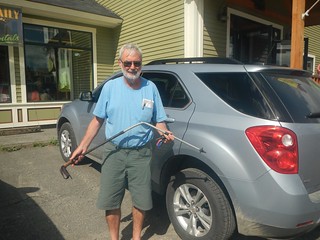
My wife Hedy, oldest daughter Vivian, and I arrived at the Sterling Inn, Caratunk, Maine, mid afternoon Saturday, June 27. This was to be my final section of the Appalachian Trail—Caratunk to Katahdin, 151.3 miles. Unfortunately, I was under the mental constraints of thinking that my last two years in New Hampshire and Maine were the toughest part of the AT. I was mistaken as this final section proved every bit as difficult. Maine is just plain relentless. There is no let up and no days off. Vivian and I were about to embark on an exhausting two weeks of strenuous hiking and we didn’t even know it.
In the early evening of our arrival, Hedy and I set out on a short hike to Moxy Falls, the highest falls in Maine. The falls were conveniently located near Caratunk and Eric, the Sterling Inn proprietor, had given us directions. We arrived at the parking lot and hiked about a mile to reach the falls. It was 7:00 pm. The adrenalin was flowing. I couldn’t wait to hit the trail in the morning and put some AT miles behind me.
June 28 to July 1, 2015
Caratunk to Maine 15
This part of the hike was Map 4 of the Official Map and Guide to the Appalachian Trail in Maine. I had completed Maps 7, 6, and 5 the previous year. These are great maps as they show a contour map, a topographic map, and an illustrated map with commentary.
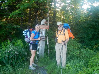
I had budgeted 2 nights and 3 days for this part of the section. It took us 3 nights and 4 days and instantly awakened us to the fact that this was difficult terrain. We set off in a light sprinkle Sunday morning (June 28). The option of waiting a day was never considered. We just took off and hoped the rain would subside. It never did. Hedy walked with us about 3 miles before turning back to the trailhead. She has often done this on the AT hikes when dropping us off—walk a few miles with us and then return to the car and her plans for the day. A few minutes later it began to rain harder. We continued to the Pleasant Pond Lean-to where we took shelter but we were drenched. Our raincoats had not shed the water. It was a cold rain and we shivered in the lean-to and began to consider our options. This was our first day on the trail and we had only completed 5.7 miles. Our equipment was drenched and so were we. We opted for plan B—take the Boise-Crossover Rd back to Caratunk, get dried out, and try again tomorrow. The Boise-Crossover Rd was about .5 mile south of the lean-to and so we set out for it. Once on the road we began an ambling walk back to Caratunk and were fortunate to get picked up by a local and delivered to Sterling Inn where we surprised Hedy. This was an inauspicious start to our adventure but in hindsight we should never have hiked on this day.

The next morning (Monday, 6/29) Hedy delivered us back to the Boise-Crossover Rd and we were off again. The Pleasant Pond Mountain was our first peak and it was a challenging one. We had to navigate around several blow downs and the trail was still wet and slippery from the rain. We arrived at the Bald Mountain Brook Lean—to in the early afternoon and decided not to chance getting our stuff wet again. We opted for the shelter. The shelter gradually filled to capacity as the afternoon wore on. Everybody was a south-bounder except for us. They were interested in knowing I was on the final section of my 12 year journey and each of them had there own story to tell. They had all started at Katahdin and then were into the 100 mile wilderness. The fact that they had completed the 100 mile wilderness gave them great satisfaction. I was thinking to myself—you don’t have a clue as to what you are about to get into. As it turned out, it was me that didn’t have a clue. Completing the 100 mile wilderness had given each of them confidence, and rightly so.
Our plan for Tuesday (6/30) was to get to the next lean-to (Horseshoe Canyon). We crossed over Moxie Bald Mountain and arrived at Bald Mountain Stream, our first real ford. I believe it was this spot where Bill Bryson (A Walk in the Woods) describes slipping, falling awkwardly, almost comically with his boots that were tied to his pack swinging around and smacking him in the head. He found himself in the stream, on all fours, when a passing hiker asked him “Fall down?” I’m pretty sure we located the spot and it is still slippery.
Vivian fell ill with a headache in the early afternoon. We were short of the lean-to by 3 miles. Coincidentally, we had stopped at a trail magic drop for a soda and there was a level grassy area where we could pitch our tents. This left us 3 miles short of our goal but we figured we could walk into HY 15 the next day (12 miles) as we had little altitude to gain. In the morning, Vivian was back to normal.
We forded the east branch of the Piscataquis River. About 1 hour from HY 15 it began to rain again. Just as I arrived at HY 15 I caught some slick granite and both feet went out from under me. I jammed my pole hard into the ground and I could feel it bend and break as I did a slo-mo fall. Thank God for the poles and I wasn’t hurt.
This concluded our first part of section 12. We had to take a zero day to dry out and get my pole fixed. We also had to stock up supplies for the 100 mile wilderness. Our day off was going to be a busy one.
July 3 to July 11, 2015
100 Mile Wilderness
HY 15 to Abol Bridge
The 100 mile wilderness was a shock to me. I had no idea that the difficulty would be so high. This was as challenging as any of the other New Hampshire and Maine sections and I was thankful to reach Abol Bridge. I didn’t think much about Katahdin and how close I was getting to the end of the journey but I did think a lot about reaching Abol Bridge and getting relief from the AT. The 100 Mile Wilderness is covered by Maps 3, 2, and 1 of the Official Map and Guide to the Appalachian Trail in Maine. I had anticipated 7 nights and 8 days to complete this part. It took us 8 nights and 9 days. We were running out of wiggle room to complete the run to Katahdin. Some thoughts on the hike to follow…
Hedy dropped us at HY 15 in the early morning of Friday, July 3 and Vivian and I marched through roots and rocks to the Wilson Valley Lean-to. This was a bit more than 10 miles. We had hoped to make 12-15 miles a day but we could only do what the AT would give us. While there was not much gain in altitude the trail was very rugged.
Our goal for the second day (7/4, Saturday) was the Cloud Pond Lean-to. This involved climbing Barren Mountain. I remember thinking that evening, while lying in my tent, wow-just 19 miles completed. Feels closer to 50. The going was pretty slow. We had only done about 9 miles and the next day was going to be a series of peaks—Fourth Mountain, Third Mountain, Columbus Mountain and we would stop at the Chairback Gap Lean-to. Interestingly, it was this area, Cloud Mountain Pond to the Chairbacks Lean-to, where Bryson and Katz got separated. You can reference A Walk in the Woods, Chapter 18. When reunited they decided to leave the AT at the logging road to Katahdin Iron Works.
It was our third night and we were only 26 miles into the wilderness. The next day we would hike into Map 2 which is a nice psychological bit of positive reinforcement. Map 2 shows we have a challenge with the White Cap Mountain and then the terrain becomes kinder, gentler (exaggerating) until the Abol bridge. So, getting over the White Cap should allow us to make more miles per day and get out of the wilderness more quickly. We began a routine that we actually had already been following only we were more aware of it—we would get up in the morning, silently pack, then hike all day. Only to repeat again the next day. The joy of being outdoors had been blunted. The expectation of reaching Katahdin was not thought about. It was all about getting to Abol Bridge and out of the wilderness.
Monday morning (7/6) we worked our way to the Carl A. Newhall Lean-to. This was our fourth night out and we had come about 36 miles. On Tuesday (7/7) we hiked to the East Branch Lean-to. We had now covered 46.7 miles. To date we had not had a break out hike but we challenged ourselves to make for the Antlers Campsite. We did and were now 62.7 miles into the wilderness. This day’s hike (7/8) was 16 miles, our longest effort of the entire section.
Thursday (7/9) saw us do 12.6 miles (Wadleigh Stream Lean-to) and we now stood at 76.3 miles into the wilderness. We had also moved to Map One and that was very positive.
Friday (7/10) we arrived at Rainbow Spring Campsite, just 11.2 miles from Abol Bridge. The next day, Saturday (7/11) we ran into Hedy who was hiking out to meet us from Abol Bridge. Glorious day. We had made it. And it was tough.
July 13 to July 14, 2015
Abol Bridge to Katahdin
Monday (7/13) I hiked 10 miles of the AT with Hedy. This was from Abol Bridge to Katahdin Stream Campground. The hike was on a decent trail, and only a few hundred feet of altitude gain. It was a pleasant hike—no other hike in Maine was like this one. We passed water falls and followed the Nesowadnehunk Stream for much of the way. Hedy and I arrived about 1:30 pm, and Vivian picked us up about 1 hour later. We all three planned to summit Katahdin on the next day.
Tuesday (7/14) had arrived. I had been hiking to this date for 12 years now. This was it. This was my day. Hedy and Vivian were going to join me in summiting together and celebrating the moment. That was the plan, anyway. What really happened was a bit different. I had underestimated Katahdin, thinking it was just a day hike. I assumed the trail would be well laid out, rock steps, zig zags up the really steep parts, but once again I had misjudged the AT. Kathadin was a monster. And it was a monster that lured you in to its trap and then ate you alive. By this I mean that when we left Kathadin Steam Campsite we were 5.2 miles from the summit. Quickly, after walking along a gentle trail, Katahdin Stream and Katahdin Steam Falls we were only 4.1 miles from the summit and had only been walking for an hour or so. It was still early in the morning. However, the second mile the climbing became more serious and by the time we reached a section called The Cave, it had basically been rock climbing and scrambling. Hedy was super. She is short, has short legs, but is very tough. She would clamor over a boulder and then walk a few paces and be confronted with another. Around 11:00 Hedy released me to go ahead. We had reached the tree line but it was evident that the hiking was not getting easier and the chances of her summiting in a timely manner were nil. So I left my wife and Vivian and I continued to the summit. At about the 3.5 mile mark we reached a level section called the Gateway. The trail is rock strewn but not steep and you could see the hikers gathered on the summit over a mile away. It began to sink in that the journey was coming to an end. Several hikers heading down from the summit stopped and asked if I was the hiker who had been doing the AT for 12 years. Congratulations! Nicely done! It was very gratifying. A group of young people Vivian and I leapfrogged multiple times from the Antlers Campsite passed us and we chatted a bit. On the way back down from the summit they stopped and congratulated me. It was an awesome time.
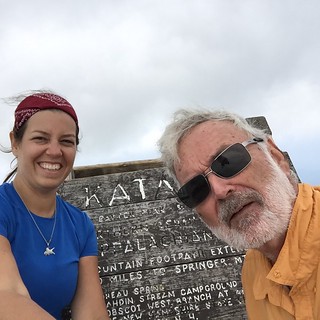
At the Thoreau Spring I was marking my last mile on the AT. Bitter sweet moments. About 50 yards from the summit I choked up, swallowed air and had to collect myself to continue. This was my emotional moment. I had no idea what form it would take but it wasn’t so bad-just a few seconds of gasping for air as the sense of my accomplishment swept over me. No time to dwell on it, we have to touch the sign and get back to Hedy.
We reached the summit at 2:27 PM, took a few pictures, and then set off on our downward trek to catch Hedy. We were concerned about her as the terrain was wicked. We caught up with her about 2 miles from the Katahdin Stream Campsite and found out that she had continued to climb after Vivian and I forged ahead. She reached the Hunt Peak when she realized that it would not be wise to continue further. As it stood, we had begun our day at 6:37 am. It was not until 8:30 pm that we were back at the Katahdin Stream Campsite where our car was parked.
