With Sophi, Royal Arch Loop
This was my third time out to the South Bass trailhead. The last two years I had a shuttle take me out, this year Sophi and I rented a Suzuki ATV in Las Vegas. It was a wonderful vehicle.
We arrived in Tusayan in the early afternoon—Thursday, March 13.
Selected photos from the hike.
Friday, March 14, 2008
We left the Seven Mile Inn early in the morning and turned onto the Kaibob National Forest Road 328. It took us more than 2 hours to negotiate this wild road to the South Bass Trailhead. About halfway into our journey I noticed that we were quite low on gas. This unfortunate information stuck in my head for the remainder of our hike and then the drive back. We encountered numerous deer and elk. The road crosses a portion of the Havasupai Indian Reservation but nobody was there to collect the toll.
FR328 from John Hayes on Vimeo.
At the trailhead we ran into another hiking party of 4 guys, middle age. They had locked their keys in their vehicle and had collaborated in coming up with an ingenious tool for opening the door. They had only just succeeded when we pulled in. They were hiking the Bass to Boucher trail, a route I had done the previous year. So, the first mile of our hike would coincide with theirs.
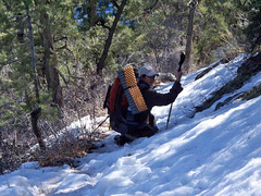
The short descent to the Esplanade was covered with patches of ice and snow. But the day was clear and warm and crampons were needed for just a quarter a mile or so and probably not needed at all. At the Esplanade was a large cairn that marked our turn to the west along a pack trail. The pack trail followed a contour to Montezuma Point were we intersected a tributary to the Royal Arch Creek. This was the point where the hike became quite difficult with much boulder hopping and route finding. And it was a time of commitment because there was no turning back. It would be too difficult to climb out what we had just climbed into.
And then we reached the spot that I had misdiagnosed as the impassible pour-off on my hike out here last year. This time I was confident we would locate cairns and find the proper way down. But, Sophi and I spent about 45 minutes going back and forth along the pour-off trying to find a path down. It was looking like a repeat of last year and I had no desire to jump to a descent point again. Fortunately Sophi scouted an overview area by jumping about 5 feet and then exploring along the ledge and peering over. It appeared to her that we could work our way down at this point. After a bit of coaxing, she guided me down the 5 foot or so jump and I confirmed that she had found a path down to the canyon floor. We worked our way down and set up our first camp. It was a tough day’s hike.
In-the-field reports
************************************
Saturday, March 15 was an extremely difficult day. We started early and spent much of the day struggling across boulders and walking through water. Somewhere on this hike we hit a patch of the trail that was along a steep slope and covered with small round rocks. I approached Sophi to warn her to be careful as it was like walking on ball-bearings but my feet went out from under me and I began a flip flop down the slope and out of Sophi’s sight which scared her. I rolled for maybe 20 feet and then collected myself, checked to make sure everything was intact and called out to her that I was OK. And that was that. A nasty little spill but I was none the worse for it.
The side trip to the Royal Arch was only one-quarter of a mile but it took more than two hours to visit the arch, snap a few photos and then continue on with the hike.
After returning to the trail from the Royal Arch we had a steep hike out (after locating the cairn-marked trail) that took us to the Tonto plateau. We expected to make it to the Colorado River at Toltec Beach and camp there but there was no way we could do that. In fact, we would have to camp early and do the rappel the following morning.
************************************
Sunday, March 16 in the early morning we hit the rappel site and were quickly over the edge. I got a great video of Sophi doing the rappel. It is only a 20 foot drop but we’re not experts at this and so it is a bit daunting to have that part of the trip ahead of us. We were happy to complete it and head on to Toltec Beach.
Rappel from John Hayes on Vimeo.
Along the way I passed the cache of supplies from the previous year and just neglected to check it. Maybe next year when I return with Jesse.
We breakfasted at the beach, stored our equipment away from the river, and headed out for Elves Chasm. Very rugged trail. We found ourselves using our gloves to protect our hands as we braced against the volcanic rock. When we arrived at Elves Chasm both of us were quite tired and it was starting to cloud up. So, we did not go up the canyon to the waterfall. This is the second time I have been at Elves Chasm but not be able to go to the waterfall. March, 2010 is my next planned trip back and hopefully I’ll make it then. That will be my goal.
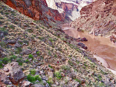
The Royal Arch flows into the Colorado at Elves Chasm. It is a great place to get good water and we loaded up. This water had to last us for the rest of this day and all day Monday. We were in a rationing mode.
After returning to Toltec Beach we prepared lunch and then rested for an hour or so. I can’t stress enough the fatigue we were experiencing, especially me. When it began to sprinkle we decided to move forward to Garnet Canyon. It continued to rain, not very hard but steady. At one point, since I didn’t bring my rain cover for the pouch, we stopped and used the tent shield. Sophi tucked it around my pack and that kept things pretty dry.
Just before entering Garnett Canyon the rain let up and we were at a good camp site. So, we set our camp up and it was fortunate that we did. As soon as we had the tents up the rain started up again. It lasted for another couple of hours, a steady drizzle, and then stopped. It is the first time I have had any prolonged rain while hiking in the canyon-which explains why I didn’t have my rain cover. Never again.
************************************
Monday, March 17 The rain stopped in the early evening and we quickly dried out as we descended into Garnet Canyon, crossed it, and then began to work our way out the opposite side. Garnet Canyon is a bit tricky but I did recall last year’s path finding and we had the tracks on the GPS. Still, we decided to exit a bit earlier then I had on the previous year and found ourselves doing a bit of rock climbing (to save maybe a mile or so). When we arrived at the Tonto plateau it was quite disconcerting as we could not distinguish any trail at all. According to the GPS if we continued along the plateau at our current contour we would junction with my campsite from the previous year. This was just a large, flat rock where the trail crosses a dry wash but it is easily recognizable. In a few minutes we had happened onto the trail again and by 10:00 or so we had breakfast at that flat rock. This hike was a tough one for me and it was the longest of our hike. I believe we covered about 12 miles, maybe a bit more. From Garnet we crossed a couple of unnamed canyons and skirted beneath Fisk Butte. We had views of several rapids. We entered the large Copper Canyon but unfortunately no water. This meant we had to keep pushing to the Bass Trail. I had marked a large water hole about 6 tenths of a mile below the junction of the Tonto with the Bass and that was where we planned to get to. We arrived in the early evening, tired, but thankful to have plentiful water and know that tomorrow we would be hiking out.
************************************
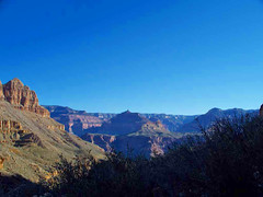
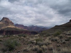
Tuesday, March 18 This is the day that we hike out. We started early and made steady progress as we were ready to get out of the canyon. After an hour we could look back at our progress. The South Bass trail provides some wonderful vistas. One prominent vista is Fan Island. We saw this pointed geologic structure for most the day Monday and some of today. I remember first seeing this when I did my first hike into Bass Canyon in 2006. I have always been unsure of its identification but after looking at my GPS tracks and the photos taken during this hike and then using Google Earth and the topo maps I’m quite certain that it is Fan Island. I have it marked in the selected photos.
The trip back, as I mentioned earlier, was a bit heart-stopping. Within a mile of leaving the parking area the low gas indicator came on. We still had 30 miles to go which I was fairly certain we would have enough gas for, but that was still a two hour drive. That is a long time to go with a low gas light. Fortunately it was not a problem as the trip back went without a hitch.
