This spring break I hiked in the Grand Canyon with daughter Nataly and her husband Josh. We arrived in Tuscayan late in the evening of Saturday, March 8, 2014. The next morning we were hiking into Phantom Ranch by way of the Bright Angel Trail.
Josh and Nata ready to explore the Grand Canyon. We started out with a hike to Phantom Ranch and throughout the week (March 9 to 13, 2014) made day hikes to Santa Maria Springs, Horseshoe Mesa, and Plateau Point.
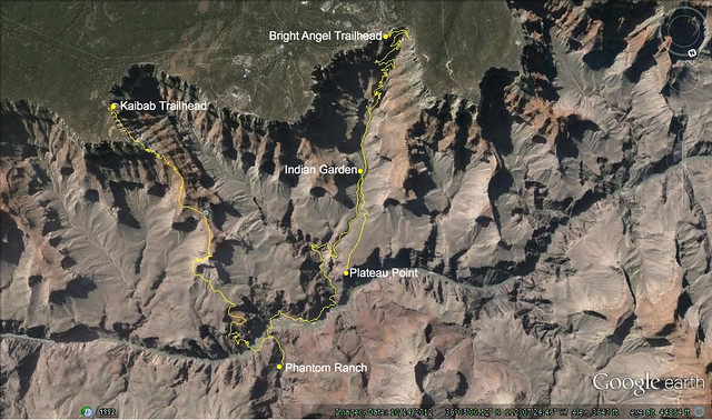
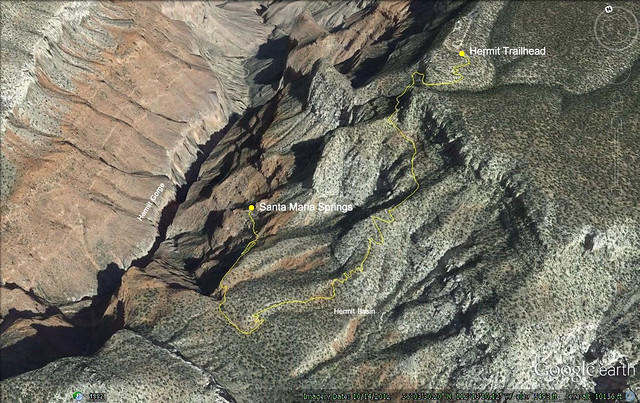
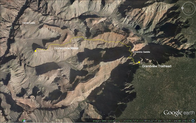
Here are the GPS track images of our hikes—
Bright Angel Trail to Indian Garden and Phantom Ranch. Return by Kaibab Trail.Day hike to Santa Maria Springs.GPS tracks of Grandview Trail to left arm of Horseshoe Mesa. Day hike, March 12, 2014.
I had completed, for a couple of weeks now, the AT page describing the 2012 section hike with Mom and Nata. The page contains a couple of audio files that captured Nata’s and my impressions of our Blair Witch experience. It also has links to the photos taken by Mom and myself.
I will be making a few more tweaks to it as new thoughts occur to me.
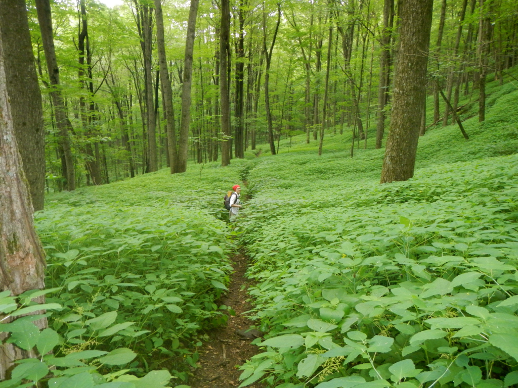
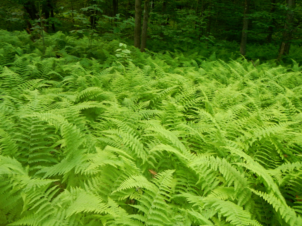
The photo to the right is one of my favorites. As you can see, Nata and I are continuing our hike into the deep forest. Pretty cool.
The page, like all the others, is linked form the menu bar above at AT > [AT-2012-Conn, Mass, Vt].
Last July 17 I returned from the Appalachian Trail for 2012. This was a difficult section on par with my first hike on the Royal Arch in the Grand Canyon. After both hikes I was “hiked out”. Hopefully I’ll get back to Government Canyon this coming weekend.
I’ve begun work on the photos for the AT 2012 page I will eventually post on this blog. I began the hike at Conn 41 just outside Salisbury, Conn at mile 689.7 from Katahdin. Hedy and Nata joined me for the beginning of most of the day’s hikes. Nata hiked with me for one week before she had to return to San Antonio.
I concluded this 9th section hike at Stony Brook where there is an access road with a small pull off area for the car. This is fairly close to Killington, Vermont. My Appalachian Trail Thru-Hikers’ Companion does not have a mileage marker for this although it is a prominent parking pick up on their official maps. The Stony Brook Shelter is about 1 mile from this point and that is listed at 477.9 miles to Katahdin, so I will use that figure to conclude the 9th section hike.
The total miles covered for the 9th section is 211.1 miles. That is my best to date. However, it has come at a price as I returned exhausted and had to jump back into work immediately. It was nice to be able to hike with Nataly on several extended hikes and it was great to start the hike with Hedy who provided excellent support and shuttling. Stony Brook parking area is about 35 miles from the Vermont-New Hampshire border. That means most of my 10th section hike, God willing, will be in New Hampshire. The AT goes through New Hampshire for 161 miles. I should get quite close to the Maine border next year but might not make it. It will be difficult to maintain the pace I had for the 8th and 9th sections. However, with Hedy coming and doing the shuttling it does provide me with opportunity to increase my mileage which is so important now. I would really like to finish this.
We leave for the AT Saturday. Hedy and Nata are both joining me for this 9th leg of the trek. Hedy will provide shuttle for Nata and myself. Nata will hike with me for one week before returning to San Antonio. I last hiked with Nataly in the Grand Canyon in 2003. We hiked down the Kaibab and stayed 2 nights at Phantom Ranch. We also took an extensive side trip on the Clear Creek Trail before returning to the South Rim via the Bright Angel.
This year we will begin the AT at the exact point I left it last year, as always. This will be a spot very near Salisbury, Conn., about 7 miles from the Massachusetts border. We are planning on camping the first night as there is no good exit point. We plan to exit the following day at the 30 mile mark where Hedy will pick us up. That is a pretty aggressive goal but that is basically what I was doing last year and feel that we can maintain it. Nataly is in good shape, not overweight, and has geared herself up for this.
We will be HQing in Duncan, Mass. That is about 60 miles north of Salisbury and Nataly and I plan to make it in 4 days.
I’ll let you know how it goes when I return. We will be on the trail July 1 and our final trail day will be July 16. I plan to be near Rutland, Vermont at that time. We are flying in/out of Logan in Boston.