Posted on

Reflections on Katahdin

It has been two months now, since Vivian and I summited Katahdin. This was my last day of a 12 year journey on the Appalachian Trail and, just to make things interesting, I underestimated what we were getting into.

Appalachian Trail 2015
GravelBoy and first view of Katahdin, from Rainbow Ledges, 20.9 miles via the AT.

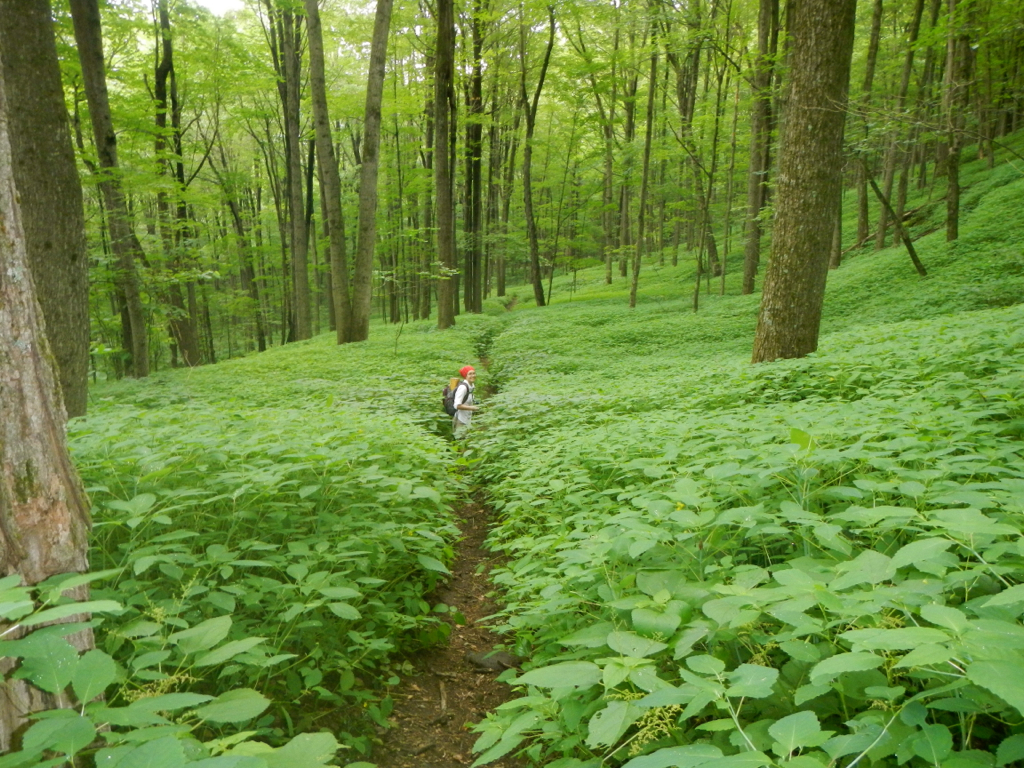
This final section hike began at Caratunk, June 28, 2015 and was divided into 3 parts: Caratunk to Monson, the 100 Mile Wilderness, and Katahdin. When I exited the 100 mile wilderness we had planned for 2 days to complete the hike. The first day Hedy and I would hike from Abol Bridge to the Katahdin Stream Campground (about 9.9 miles) and the final day Hedy, Vivian and I would hike 5.2 miles to the summit and then return by the same route.

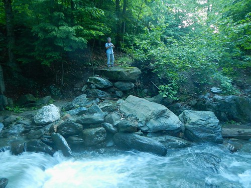
We left Millinocket at 5:30 sharp on the morning of the 14th. The drive to Baxter State Park (south gate) is 17 miles over a paved, local road. Once inside the park the road narrows to a graveled road with speed limit 20 mph. In another 7 miles we reached Katahdin Stream Campground (1080 feet) where public parking is available for day hikes.

We began our final summit hike at 6:40 am, July 14, 2015.

I had done no prior reading about Katahdin and only had the impressions from Map 1 of the Official Map and Guide to the Appalachian Trail in Maine. According to the topographic map the climb was going to be a steep one but I had been on other steep climbs. I made the assumption that since Katahdin was the northern terminus of the AT, that it is a well known and popular trail, that the steep grade would be taken care of by a series of switchbacks and stone stairs. I do not know where this idea came from but I do know that you should never underestimate the trail. But in this instance, I did.

The three of us started out from the campground parking area at about 6:45. In 40 minutes we had covered 1 mile and were lulled into a sense of “this isn’t bad at all”.  Just 4.1 miles to the summit and the end of my AT journey.

Appalachian Trail 2015
Hedy, finding a pathway over the boulders.

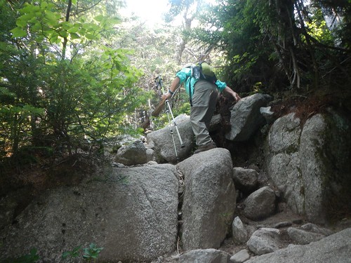
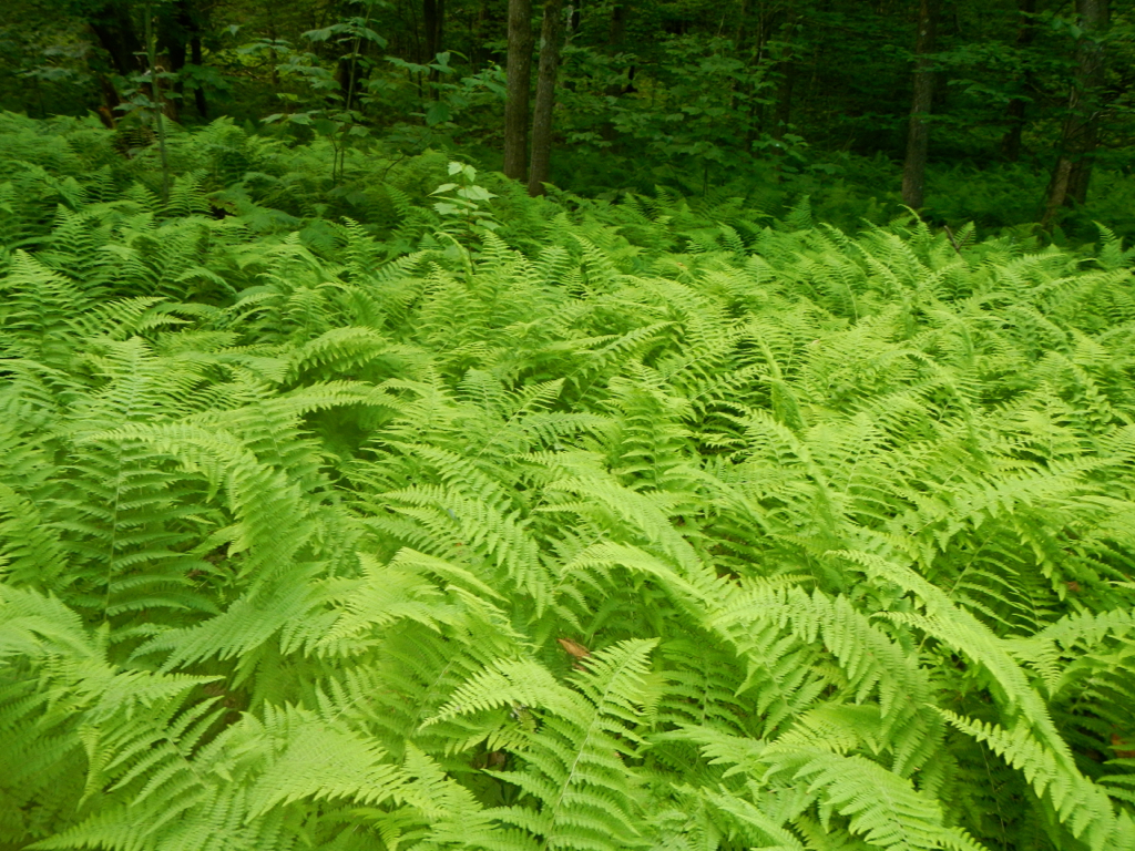
But the trail began to ascend more steeply. After another mile we began to negotiate larger rocks and a painfully-slow problem solving process to move forward. Vivian left Hedy and I and headed for the tree line at about 3500 feet and waited for us. We would not join up with her until 11:15 am.

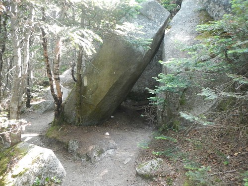
At 10:36 Hedy and I reached The Cave-described in the map as a “small, slab cave”. We were not making good time.

We had 2.5 miles to go. It had taken us almost 4 hours to get to The Cave and we could only surmise that the trail ahead would not get better.

Appalachian Trail 2015
The Cave, on the AT in Maine. Katahdin summit is 2.5 miles and the trail gets much steeper.

When we joined Vivian, Hedy sent the two of us ahead to finish. She realized that we would arrive very late in the afternoon if she continued the ascent with us. Vivian and I were nervous about leaving Hedy but there were a number of other hikers coming and going and we really had no choice for me to complete the AT. Just 2.5 miles to the prize!

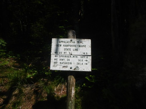
We continued above the tree line through a boulder field. There is no trail, only white blazes to guide the way. At 12:15 pm Vivian and I reached the 2 mile mark. We could see the False Summit” and at 1:10 we reached it. Vivian and I had been told about the False Summit by a hiker named Kyle at the Bald Mountain Brook Lean-to, a couple of weeks earlier. He had some great photos he shared with me and warned me about the False Summit”. It appeared to him, and his fellow hikers, that they were approaching the real summit only to find that they would still have another 1.6 miles to go. As you climb toward the summit you can clearly see a sign that adds to the impression that the real summit, the end of the AT, is at hand. However, the sign only warns hikers to stick to the trail and the actual summit can be viewed in the distance..

The False Summit actually turned out to be The Gateway and was clearly marked on our map. We were now 1.6 miles from the actual summit. The nice surprise−we were at the edge of The Tableland. We would have relatively level hiking for about 1 mile before beginning the final ascent to Katahdin.

Appalachian Trail 2015
False summit even comes with a sign, on the AT in Maine.

At the 1.0 mile mark we reached Thoreau Spring (4627 feet). Several hikers who had passed us earlier in the day stopped to chat with us on their return from the summit and congratulate me for being so close to completion. Vivian and I had been leapfrogging with a youth group starting from Antlers Campsite (about 50 miles south). They stopped on their return trip from the summit and congratulated me. It was gratifying to have these folks recognize the accomplishment. Vivian and I continued on. We could see the summit now and the white blazes leading the way.

At 2:27 pm we summited.

Vivian and GravelBoy at Katahdin summit

We did not stay long, just under 15 minutes. We took a few photos. There were perhaps 15 to 20 people at the summit. We were anxious to get back to Hedy and off the mountain and as we descended to Thoreau Springs a cloud cover engulfed the summit and a strong wind began to blow. We soldiered on. At The Gateway we descended into the boulder field and had to navigate carefully and slowly. Views were spectacular. We found ourselves “waiting in line” at a couple of bottle necks just above the tree line.

Once we hit the tree line we had a trail again, although covered in boulders so the going was slow. Below The Cave the trail continued to improve as we could follow stone steps now, for the most part. At 6:20 pm we reunited with Hedy. She had not waited for us but had continued to climb and had actually reached the False Summit before turning back. We were very proud of her, and her efforts this day were inspiring. Hedy is tough.

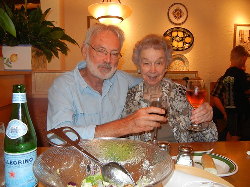
We were still about 2 miles from the parking lot. Hedy and Vivian wanted to celebrate our reunion by eating dinner. We had a Greek salad. I was very uncomfortable sitting. During the 100 mile wilderness I had two hard falls and was feeling the effects. One fall was a pratfall. Nothing pretty about that. But, as I sit at my MacBook and compose this posting, I can still feel the effects on my tailbone. Very slow to heal. The other fall was on my right side, hitting the ground hard. My pack absorbed most of the blow but there was an exposed tree root that punched me in the side like a fist. This caused problems sleeping in the tent as I could barely turn from my right side to my back to my left side and repeat. This is my normal “sleeping procedure”. This “punch” continued to linger with me for the remainder of the hike. Because I was so uncomfortable, Hedy and Vivian sent me on ahead to the parking area.  I arrived about 7:30. It would not be until 8:30 that Vivian and Hedy would arrive. That makes for a 14 hour day! Hedy and I were completely exhausted from the day, Vivian was not. She walked with her mom and encouraged her along the way. Vivian is tough.

Posted on

AT 2015 Trip Report Ready

Vivian and I summited Katahdin, July 14, 2:27 PM, a date and time etched in my memory forever. The next day Vivian returned to San Antonio while Hedy and I flew into Omaha, rented a car, and drove into Lincoln to celebrate the occasion with my mother.

Appalachian Trail 2015
Lincoln, Nebraska: GravelBoy and Mom toast to the completion of the Appalachian Trail.

We arrived in the wee hours Thursday morning, July 16. I was back to work on Monday, July 20. I mention all of this because it takes quite a while to make a trip report and even longer to gather photos, cull them, tweak them and then upload them.

But I finally have things ready to go.

Trip report at https://gravelboy.edublogs.org/at/at-20015-maine/

Selected photos https://flic.kr/s/aHskhqXGQS

A note on the photos—there are quite a few photos of gravel roads, logging roads, signs. You might ask “why include these?” My response—these are location photos. They allowed Vivian and myself to know exactly where on the map we were. I have tagged the photos with the map name so anybody searching for “Long Pond Road” on the Appalachian Trail in Maine should get a photo of it. Believe it or not, these photos provided a sense of comfort, knowing exactly where we were.

Posted on

Done!

Vivian and I summited Katahdin, July 14, 2015 at 2:27 PM. My AT journey is over.

Appalachian Trail 2015
Vivian and GravelBoy, on the summit of Katahdin, on the AT in Maine.

This final section (Caratunk to Katahdin) was as challenging as anything I faced in New Hampshire and Maine. This surprised me a bit as I fully believed I had completed the most difficult sections on the AT. This last section was equal to them.

Vivian, my oldest daughter, hiked 141 of the 151 mile section with me. The only section she did not hike was the 10 miles from Abol Bridge to Katahdin Stream campsite. My wife Hedy walked that section with me-the easiest 10 miles in Maine. The other 141 miles were challenging.

Over the next couple of weeks I will be developing my trip report and going through my photos. I will have a static page for this final section hike, just like for the others. Selected photos will go on Flickr.

Posted on

151.3 to Katahdin

Saturday, July 19, I arrived back from my 11th year on the Appalachian Trail. Going into this section I did not know how difficult it was going to be. I had hoped that I had the worst behind me but actually this section was harder than last year’s. The hike began at the summit of Mount Washington on June 26, about 9:00 am. Hedy and I arrived in Portland the day before, picked up our rental car, and then found HQ in Gorham, NH. It rained the entire day and well into the evening. I was uncertain if I would be able to set off on the morning of the 26th but the weather had cleared and we were the first ones to enter the auto road for Mount Washington.

The starting point was 332.5 miles from Katahdin. I crossed into Maine in the early morning of July 2 (281.4 mile mark) and stopped at Caratunk, Maine, July 17 (151.3 mile mark).

Appalachian Trail 2014
New Hampshire/Maine state line, on the Mahoosuc Trail, on the AT.

Every day was a tough hiking day. I took a zero day after perhaps the most difficult stretch of hiking in my life. This was the final New Hampshire section (HY 2) to Grafton Notch in Maine. This stretch was 31 miles and I divided it into hikes of 12, 9 and 9. The last hike included Mahoosuc Notch, Mahoosuc Arm and Speck Mountain. I was exhausted when I exited the trail and thankfully it rained all night and the next day and gave me a perfect excuse for a zero day. This was July 4th. I took a second zero day on July 8th. I had broken my pinkie on my left hand on the first day hiking (Mount Washington) and Hedy and I drove into Rumford, Maine to have it checked. We picked up Vivian and Andrew at the Portland Airport that evening so it seemed like another good excuse for a zero day. Other than that, it was hiking every day. Most of it very challenging.

Like last year I found that while the trail was extremely difficult that the experience and beauty offset that. This was my best section yet, even better than last year. I am nicely positioned to complete the AT next year, which was my goal. Over the next few weeks I will be working on my page providing details of this 11th year and uploading photos.


Posted on

Four more hikes

I realized, in anticipation of the upcoming hike on the AT, that I have a few key hikes left to complete two major hiking milestones in my life. One major milestone  is the completion of the Appalachian Trail and another that I have not been consciously working toward, would be the completion of all hikes on the south rim of the Grand Canyon. Here’s how I hope it plays out—

Hike 1: June-July, 2014, 11th section of the AT. I am currently at the summit of Mount Washington and should set off June 26, 2014. I will hike as far into Maine as I can manage, understanding that the situation is much more difficult than in previous sections. The hiking last year was hard fought and I expect more of the same the final two years.

Hike 2: March 2015. I plan to do the Escalante Route with Vivian. I had hoped to do this in 2012 but was not able to get the permits. This will be a challenging hike and I’ve asked Vivian to join me for this as it involves some route finding and common sense. This is not a hike I would want to do alone.

Hike 3: July, 2015. This should be the final section of the AT to Katahdyn. I’m hoping the milage will be low based on the 11th section endeavor. Certainly this could be an emotional moment in my life.

Hike 4: March 2016. The final gap for the south rim trails is the Tonto Trail from Horseshoe Mesa to the South Kaibab. This is a contour run along the Tanto plateau with a stiff hike out the South Kaibab. The completion of this hike will fill all blanks on my South Rim map. And, most of the trails I have hiked multiple times, i.e. The Royal Arch Loop 3 times, Bright Angel and South Kaibab 5 times, Hermit Trail 3 times, Grandview Trail 6 times, South Bass Trail 2 times.

Right now my mental and physical preparation is for the Whites and Maine. I am really looking forward to this one. Hedy and I plan to fly into Portland, Maine, rent a car, and headquarter somewhere near the border where the AT crosses, probably on the Maine side.

I continue to hike in Government canyon on weekends.


Posted on

AT 2013 Posted…

From June 30th to July 15th Hedy and I explored new territories, experienced adventure and created memories. This was my 10th year hiking on the Appalachian Trail and it was easily the most rewarding one. This section began  at Stony Brook in Vermont and is approached by a rough access road. Fortunately we had a local map with a place listed on it called Notown. It does not show on the official AT map but is very close to the marked parking area. Notown happened to be in our Tom Tom  so we were able to arrive without problems and get off to a quick start.

Appalachian Trail 2013
Common hairmoss (Polytrichum commune).

The posted page for AT 2013 details the hike. I did better documenting this section then any of the previous 9 hikes. Photos are posted in Flickr and some thumbnails appear in daily entries—just to provide a flavor for the hike.

July 15th I arrived at the summit of Mount Washington. That is where I will begin the AT2014. I will try to squeeze out a few extra days for the 2014 hike. Once I hit the White Mountains things really changed—the trail was so difficult there were days I only managed 8 to 10 miles. The views were spectacular and other-worldly, especially above the tree line. I rued having to stop at Mount Washington. Four more days I could have completed the Whites and been at the border with Maine. I had a rhythm established, my confidence was high, Hedy and I were working well together in planning pick up and drop off points. I was a good 40 miles below my expectations for this hike due to the Whites. Looking ahead, 332 miles to Katahdin, I don’t really see much relief—no easy days that’s for sure. So, divide 332 by 10 and that’s 33 more days on the trail. I really need to get well into Maine in 2014 to complete this in 2015.

Posted on

AT 2013

I’m back from my 10th year of section hiking the AT. This has got to be my favorite one. Right now I am working on the photos and have a new account with Flickr that I am familiarizing myself with, so this will take a bit of time. Here is beginning of this 10th section hike—

Appalachian Trail 2013
Hedy is poised on the opposite bank of Stony Brook, my starting place for the 10th year of section hiking on the Appalachian Trail. This is Vermont, section 3, about 477 miles from Katahdin. Although the official AT map shows a parking area, there is only a small place on a dirt road to leave a single car. There are no services nearby so this is not a good place to get off or on the trail. The bridge was washed out and I had to begin this section by fording Stony Brook which had a suprising flow of water. This marks the first day of my 10th year on the AT. Vermont, section 3, 477.3 miles to Katahdin.

Fortunately, Hedy and I marked the GPS coordinates of this position when we got off the trail last year. We headquarted at a Super 8  in White River Junction to begin this 10th section. I was concerned about finding our way beck to our Stony Brook exit but—no problem. Our TomTom took us to the exact spot we had left off at. Trip report of. this section hike are posted at https://gravelboy.edublogs.org/at/at-2013-vt-n-h/

Posted on

AT 2012 page ready…

AT to Tyringham, Mass
Nataly on the AT, to Tyringham, Mass.

I had completed, for a couple of weeks now, the AT page describing the 2012 section hike with Mom and Nata. The page contains a couple of audio files that captured Nata’s and my impressions of our Blair Witch experience. It also has links to the photos taken by Mom and myself.

I will be making a few more tweaks to it as new thoughts occur to me.

The photo to the right is one of my favorites. As you can see, Nata and I are continuing our hike into the deep forest. Pretty cool.

The page, like all the others, is linked form the menu bar above at AT > [AT-2012-Conn, Mass, Vt].


Posted on

AT 2012-we’re back…

Fern Forest, on the AT, near Mt. Everett, Mass.

Last July 17 I returned from the Appalachian Trail for 2012. This was a difficult section on par with my first hike on the Royal Arch in the Grand Canyon. After both hikes I was “hiked out”. Hopefully I’ll get back to Government Canyon this coming weekend.

I’ve begun work on the photos for the AT 2012 page I will eventually post on this blog. I began the hike at Conn 41 just outside Salisbury, Conn at mile 689.7 from Katahdin. Hedy and Nata joined me for the beginning of most of the day’s hikes. Nata hiked with me for one week before she had to return to San Antonio.

I concluded this 9th section hike at Stony Brook where there is an access road with a small pull off area for the car. This is fairly close to Killington, Vermont. My Appalachian Trail Thru-Hikers’ Companion does not have a mileage marker for this although it is a prominent parking pick up on their official maps. The Stony Brook Shelter is about 1 mile from this point and that is listed at 477.9 miles to Katahdin, so I will use that figure to conclude the 9th section hike.

The total miles covered for the 9th section is 211.1 miles. That is my best to date. However, it has come at a price as I returned exhausted and had to jump back into work immediately. It was nice to be able to hike with Nataly on several extended hikes and it was great to start the hike with Hedy who provided excellent support and shuttling. Stony Brook parking area is about 35 miles from the Vermont-New Hampshire border. That means most of my 10th section hike, God willing, will be in New Hampshire. The AT goes through New Hampshire for 161 miles. I should get quite close to the Maine border next year but might not make it. It will be difficult to maintain the pace I had for the 8th and 9th sections. However, with Hedy coming and doing the shuttling it does provide me with opportunity to increase my mileage which is so important now. I would really like to finish this.

Posted on

AT Around the Corner…

We leave for the AT Saturday. Hedy and Nata are both joining me for this 9th leg of the trek. Hedy will provide shuttle for Nata and myself. Nata will hike with me for one week before returning to San Antonio. I last hiked with Nataly in the Grand Canyon in 2003. We hiked down the Kaibab and stayed 2 nights at Phantom Ranch. We also took an extensive side trip on the Clear Creek Trail before returning to the South Rim via the Bright Angel.

This year we will begin the AT at the exact point I left it last year, as always. This will be a spot very near Salisbury, Conn., about 7 miles from the Massachusetts border. We are planning on camping the first night as there is no good exit point. We plan to exit the following day at the 30 mile mark where Hedy will pick us up. That is a pretty aggressive goal but that is basically what I was doing last year and feel that we can maintain it. Nataly is in good shape, not overweight, and has geared herself up for this.

We will be HQing in Duncan, Mass. That is about 60 miles north of Salisbury and Nataly and I plan to make it in 4 days.

I’ll let you know how it goes when I return. We will be on the trail July 1 and our final trail day will be July 16. I plan to be near Rutland, Vermont at that time. We are flying in/out of Logan in Boston.