Clear Creek, Cheyava Falls, with Vivian
This was to be an exciting hike. I know that Vivian had been looking forward to this all year. When I returned from the Royal Arch with Sophi last year Vivian called me on the phone and said that she wanted to go with me next year. And now that time was approaching.
Our Permit was for 3/12/09 and hike out 3/17/09. As always the permit states Leader advised of aggressiveness of itinerary & associated risks.
Thursday, March 12, 2009
Bright Angel Trail, Phantom Ranch, Clear Creek Trail, Sumner Wash
Our plan was to leave very early in the morning, maybe be on the Bright Angel trail by 6:00 AM. I had hiked down the Bright Angel, a major corridor trail, a few years back at around 5:30 in the morning and did not see a person until Indian Garden. I was at Plateau Point by 9:00 or so. But that plan quickly ran aground when we discovered that we did not have fuel for our pocket rocket propane cooker. By the time we realized our error the supplier was closed and we would have to wait until 8:00 in the morning to get the fuel. Already the hike was beginning to unravel. Our plan was to hike to the AK9 camping location near Sumner Wash. There are a pair of large trailside cairns that mark the spot. But that is more than 2 miles beyond Phantom Ranch and the hike down to Phantom Ranch is a tough one. Getting a late start did not bode well.

We stopped at the Grand Canyon Market Place on our way to the Trailhead and picked up the fuel. We then swung by the Backcountry Office as they have a pack scale there. I was curious about the weight of our packs but had never actually weighed them. They came in at about 30 lbs, just as expected.
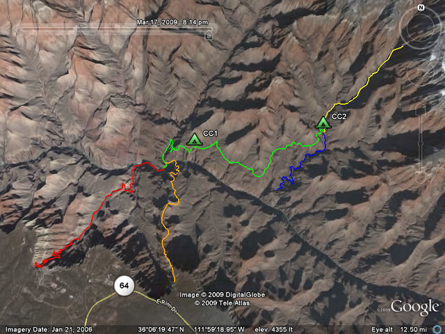
Below are the GPS tracks for March 12 to 17, 2009. Our first day would be going down the Bright Angel (red) and then a bit of the Clear Creek Trail (green). CC1 marks our campsite at Sumner Wash, about 2 difficult miles beyond Phantom Ranch. We had to climb back up to the height of the Tonto Plateau and that proved to be a couple of steep marches. We were very happy to reach Sumner Wash and set up camp.
Friday, March 13, 2009
Sumner Wash, Clear Creek campsite

Today’s hike was 6.7 miles but that was deceiving. It was long and arduous. About half way we could view the Clear Creek far below us. Our trail veered north and parallel to Clear Creek Canyon. The trail down to the campsite was treacherous, ball-bearing like Hakatai Shale. We set up our tents near the creek. This was to be our campsite (CC2 on the GPS tracks map) for 3 nights.
Saturday, March 14, 2009
Cheyava Falls
Day 3 was the goal of our year’s planning and anticipation for this hike. Today we hiked to Cheyava Falls. We did not know what to expect as the falls are seasonal.
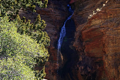
From our campsite we followed the Clear Creek trail. In a mile or so we forked to the right. By this time the Creek was dry but we continued to follow the bed upstream. The hiking, at times, was quite difficult as there is no established trail. I used the GPS to pinpoint our location and was able to get to about one-tenth of a mile from the falls. The last quarter mile was quite treacherous as I had to fight my way through the creek bed (now running again) and scramble uphill across boulders. When I looked up I saw a flow of water coming from the left canyon wall. I looked to my right and saw a feather-like falls. It was beautiful. So, we did not encounter the full force of a flowing Cheyava Falls but we did see see some falls. The tracks for this day’s hike are shown yellow on the GPS map.
Sunday, March 15, 2009
Clear Creek Campsite to Colorado River
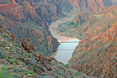
Day 4 was a hike to the Colorado River. Vivian stayed in camp to guard our tents while I set off in the early morning. According to the Clear Creek Trail flyer that the National Park Services provided us, this is a full day hike, about 6 miles one way. A quarter mile from the Colorado River is a fifteen foot drop. So, I had that to look forward to. The tracks of this day’s hike are shown on the GPS map in blue.
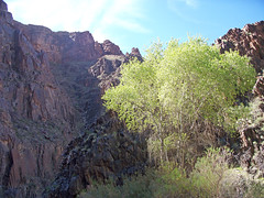
It was a nice hike, crossing the Clear Creek, beautiful weather, and several bright green Cottonwood trees along the way. Then the valley turned narrow and that was pretty cool. I reached the drop off and it looked risky considering I was by myself. So, I took a few photos and returned to camp. I didn’t want to hurt myself by attempting the climb and the risk of slipping looked fairly reasonable. To climb down actually would require about a 5 foot ascent and then a 20 foot descent. It is not straight down put pretty close to it. I think I would probably have made it down and back up OK but it was only a quarter mile to the Colorado so I had essentially completed the hike. Once again, I didn’t want to leave Vivian in a bad position by attempting the climb. I guess I’m too old for that stuff now.
I was back in camp by late afternoon. Vivian had been buffeted by winds throughout the afternoon. She had to batten down our tents a couple of times. Glad she was able to do that. I would have hated to come back and find my tent in the creek.
Monday, March 16, 2009
Clear Creek to Sumner Wash
We were ready to get back to the rim. Vivian had the idea of just walking out today, sort of suck it up big time and hike on out of there. I vetoed that. While it would be nice to have a good meal and a bath it would have to wait another day. So, we stuck to our plan and hiked to Sumner Wash. We stayed at the same campsite area CC1.
The meals were getting tough to eat now. I had experienced this phenomena before. We had a Chicken and noodle meal that almost made us vomit. Not that it tasted bad, it was just hard to eat much. Neither of us had much of an appetite but we knew food was essential. We can’t just skip a meal out here. We had a potato and beef meal as well. It was just as bad. We did our best to eat anything we could find. We were only 2 miles from Phantom Ranch so we knew we could stock up for the hike out, hopefully with food that would appeal to us.
Tuesday, March 17, 2009
Sumner Wash to South Kaibob Trailhead
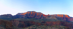
This was our final day and we were ready to hit Phantom Ranch, eat some food, and then begin the ascent out the South Kaibob. The day was a business march but in the morning I got a nice photo panorama. The photo links to a high resolution photo (3.2 MB). So, it might take a while to open.
Phantom Ranch was only 2 miles away and we arrived before the Cantina was open. But, in 20 minutes we were able to stock up. We purchased some snack foods and then ate sausage and bagel with cream cheese before starting out. The South Kaibab is very steep and we knew we were in for a tough day. The GPS tracks mark today’s hike in orange.
Thankfully it was March and still cool as we were scorched by the sun once we hit the Tonto Plateau. We made steady progress but it was grueling.
Near the top, at OOH-AH point we were strafed by condors. It was a lot of fun. We were like tail gunners trying to capture their photo.
