Section 2, Appalachian Trail
from: Sam’s Gap, 315.2 miles from Springer
to: Hampton, Tennessee, 421.5 miles from Springer
June 19, 2005 to June 29, 2005
Section 2 miles: 106.3 (pathetic)

AT 2005 section hike covers the area between Sams Gap and Hampton, Tennessee, a mere 106.2 miles. Pathetic. To describe this section in one word—debacle. Debacle is defined as a total, often ludicrous failure. So I have exaggerated a bit since it wasn’t a total failure. After all, I did add 106.2 pathetic miles to my total to date (421.5 miles).
Why was this section hike a near debacle? On the last day of the first section hike I met a thru-hiker Sebastian who shared his philosophy of hiking the AT. And he shared it convincingly. He was traveling ultra light and making over 25 miles a day. He claimed that because he was traveling so light that he required less food and water. He explained the catch-22 of carrying extra water adds extra pounds requiring extra energy to haul those pounds, requiring extra water to cool the body. The food he carried was minimal—tortilla with peanut butter, a power bar. No cooker. His equipment was the bare minimum. And as we talked about equipment he claimed it was unneccesary to purchase so much equipment for the hike. Once again he traveled with the minimum. Even his shoes were just regular tennis shoes.
Sebastian had hiked the AT before and also the Continental Divide trail and the Pacific Crest trail. I perceived him to be a professional hiker and took his philosophy to heart. That caused part of the near debacle. Adapting his philosophy as my own and then making two huge mistakes—1) overestimating my hiking ability and 2) underestimating the AT.
June 19, 2005
Sams Gap, US 23 to Whistling Gap
11.1 miles
326.4 miles from Springer
I shot out of Sams Gap and literally walked my legs out that afternoon. I started about 1PM and reached the Bald Mountain Shelter in the early evening and should have stopped there but I encountered an odd fellow there. There are a few odd people wandering around on the AT and this was one of them. Within 5 minutes he was telling me how he liked to hike in a kilt so he could flash other hikers. Needless to say I disengaged myself rather quickly and continued down the trail to find a campsite. It began to sprinkle and I just happened upon a nice flat area so I broke out my tent only to discover that I had left the poles in San Antonio. It began to sprinkle harder. I repacked and resolved to make the best of the situation. After all, it was nobody’s fault but my own. Fortunately, within 30 minutes I happened upon a rock outcropping, right on the AT. It provided adequate shelter from the rain.
I was traveling ultra-light, thanks to the advice from Sebastian the previous year, so I only had a blanket to cover myself with but it was actually OK. I survived the night without further mishap.
June 20, 2005
Whistling Gap to Erwin, Tennessee
13.5 miles
339.9 miles from Springer
The march into Erwin was painful. My legs were used up and as I write this now I marvel that I made 13.5 miles. The last couple of miles were the descent into Erwin and I could only sidestep my way down the trail.
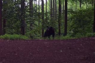
Just 2.5 miles outside of Erwin at Temple Ridge, I took a break. As I was laying down looking at my map and eating peanuts I heard heavy breathing. When I looked up I saw my first bear. It was a young one, about my size, with shiny black fur. He was not spooked and seemed to not notice me as I slowly gathered my stuff and headed down the trail.
I had to take a zero day in Erwin. My legs were shot. I purchased some hiking shoes in Johnson City but did not seek help with the purchase which turned out to be a huge mistake as they tore my feet apart during the upcoming days.
June 22, 2005
Erwin to Unaka Mountain
13.7 miles
353.6 miles from Springer
June 23, 2005
Unaka Mountain to Clyde Smith Shelter
12.5 miles
366.1 miles from Springer
June 24, 2005
Clyde Smith Shelter to Stan Murray Shelter?
11.2 miles
377.3 miles from Springer
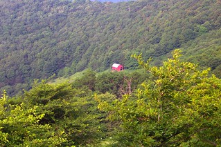
While my hiking may not have gone well, the scenery was the most beautiful I have encountered. And this is being written in August of 2009 with over 1000 trail miles completed. The Roan Mountain area began a series of hikes through open areas (balds) with beautiful wildflowers. Fantastic even though my body was beginning to feel the effects of poor eating.
June 25, 2005
Stan Murray Shelter to US 19
11.1 miles
388.2 miles from Springer
I staggered out to US 19 in the early afternoon and stood by the roadside, knees wobbling, quite weak, and hitched a ride into Roan. I was dropped at a gas station/food outlet and was able to get a shuttle back to Erwin to rethink, replan, and reequip. Things were not going very well. I needed to do better.
I took another zero day to recover. I went into an Applebees and ordered steak and a brewski and could only eat a tiny portion of it before I became nauseous and had to leave.
The following day I drove to Hampton where I made arrangements for the final leg of this doomed section hike. It would take me about 30 miles, just enough to get over the psychological 100 mile mark. Again, pathetic.
At Hampton is an outfitters where I purchased a sleeping bag (the blanket wasn’t cutting it-too cold at night), and a backpack. I had been using a simple day pack that I purchased at the Grand Canyon but it was not adequate. It was as if all the experience I had gained the previous year went for naught. I had to learn to hike smarter. Unfortunately, I kept the shoes hoping that they would “break in” but they never did. They just continued to tear up my feet for three more days.
June 27, 2005
US 19 to near the Laurel Fork
12.6 miles
400.8 miles from Springer
June 28, 2005
Laurel Fork to Dennis Cove
11.8 miles
412.6 miles from Springer
June 29, 2005
Dennis Cove to Hampton, Tennessee
8.9 miles
421.5 miles from Springer
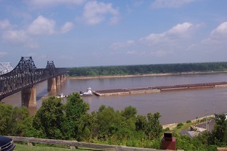
And this is where this section hike ends. I limped into Hampton, got Nataly’s pick up and began heading home. I did pass through Vicksburg on the way so I could see that famous city.
I learned that driving out to the AT is not a viable option. That cost me at least 4 trail days. I also learned that I need to eat better and more varied food as Sebastian’s diet just would not work for me. I resolved to do better next year.
