Escalante Route Trip Report
As my oldest daughter Vivian and I planned to hike the Escalante Route we researched other trip reports and, as usual, got a bunch of conflicting information. So, I intend to do my very best to provide accurate information about our experience. We each have photos and video about our experience in the Canyon—and it was memorable.
Sunday, March 8, 2015
The Escalante Route begins at Lipan Point at the Tanner Trailhead. Our plan was to hike carefully for 4 to 5 miles and camp near the Tanner Canyon overlook, just above the second big descent (“Holy Mother” trail). We started about 10:00 and quickly found ourselves off trail because of a snow covering. We retraced our steps about 100 yards and found a zig we had missed and then began to do switchbacks through the snow.
Video—Tanner Trail
About 1 mile down the Tanner we left the snow. In another 1/2 mile or so we were on the Tanner Saddle and had completed the first of two difficult descents to Tanner Beach. On the saddle is a spectacular view of Seventyfive Mile Creek. We would be hiking down Seventy-five Mile creek on our fourth day.

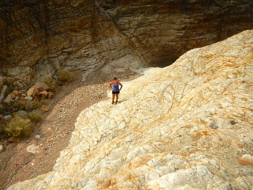
One-half mile before the junction with the second descent we set up our first campsite. This was a short 4 mile hike but even being short it was exhausting. The initial switchbacks coming down the Tanner are rated DD by Sky Terrain Trail Maps. DD is the label for Expert and described as “steep & rocky, trail may be faint, may require scrambles, may have vertical exposure.” Just before the Tanner Saddle is another particularly steep descent, this one rated D (steep, rocky or sustained grades). When I hiked the Tanner-Beamer with Sophia in 2012 we hiked to the beach campsites. This was very strenuous on my legs because of the two very steep descents. So, planning a 4 mile day was to avoid making the two steep descents in a single day.
Monday, March 9, 2015
The morning began with a 1/2 mile approach to our second descent and then down the Holy Mother.

About 1/3 of the way I took a spill, not too bad, but I was cutting across a zig and just lost my focus. I broke the crystal on my watch, tore my hiking pants in the area of the left buttock and bruised the cheek and had some scrapes on my elbow. Fortunately I was alright and after gathering myself was able to proceed down the trail. We moved carefully for the next couple of hours. Vivian separated herself a bit (she is a faster hiker) and I lost sight of her. When I arrived at Tanner Beach (3.3 miles from our campsite) I saw her backpack but she wasn’t there. She had gone off to look for me. Within a half hour she was back at Tanner Beach and we spent the next hour filtering our water. This was my first experience using the pump with muddy water. It did a good job of cleaning the water but the taste was pretty bad. I had some Aquamira drops that improved the taste considerably. The pump worked well but had to be cleaned often and would only produce a dribble into our Nalgene container. But it gave us our water that we were so concerned about
We pushed on for Cardenas Creek (3 miles) but did not read the map well. We lost about 20 minutes following the shoreline while the trail was actually above the shoreline a few hundred yards. This section of the hike is called the Escalante Route and it does not show on my GPS. So we were relying on the National Park Service’s Escalante Route flyer (last revised Feb. 2008) and the map. Once we realized it was not a walk along the shoreline we were able to find the trail and follow it in to the mouth of Cardenas Creek, where we set up our camp. We were right on our planned schedule.
Tuesday, March 10, 2015
Once again Vivian and I had an early start, not knowing what lay ahead.
The planned hike had two parts: 4.3 miles walking inland to the west fork of Escalante Creek. Then we would continue for another 2 miles to the east fork of the the Escalante and down to the Colorado where we set up camp. It was very hot. The sky was cloudless and blue and the sun scorched us as we made our wasy to the east fork. Part of the trail is covered in small, round rocks, almost like ball bearings. Of course, we were very focused as we hiked this section as the terrain sloped steeply on our right.

Once we reached the east fork of the Escalante we hiked part of the dry creek and skirted a high pouroff and then continued along the dry creek towards the Colorado. About a mile before reaching the Colorado we were rewarded with a spring. We refreshed ourselves, replenished our water and continued to our campsite. No need to filter today. The heat had taken its toll as we were both sucked dry. We had our camp set up by 5:00 or so and soon the canyon became very chilly and we were in our tents for the night. We did not know that the next day was going to be our hardest one.
Vivian’s trip report for Monday and Tuesday—
Video—Escalante Beach
Wednesday, March 11, 2015
The plan for today was to get as far up the New Hance Trail as we could, at least to a water source that Vivian and I came across in 2012 when we hiked down the New Hance and looped around to the Grand View Trail. We were really counting on that water. We made one tactical error that cost us 3 miles and this was followed by difficulty in finding the route that would take us to Hance Rapids.
Leaving our campsite at Escalante Creek we quickly made our way to Seventyfive Mile Creek, a slot canyon.
We walked along the slot canyon until we came to well-cairned spot marking a place to descend into the canyon. This was where we made our tactical error. We should have followed the cairns but we didn’t. According to our National Parks flyer about the Escalante Route —
The trail climbs away from the river below the mouth of the Escalante Creek and follows a rising ramp of Shinto Quartzite down canyon. Walk the top of this formation around into Seventy-five Mile Creek. Though there is a route directly down the cliffs to the creek bottom, a less thrilling (and probably safer) option is to walk the top of the Shinto all the way to the bed of Seventyfive Mile Creek and continue down the bottom to the river.
When I read this now, several weeks after the event. it makes sense. However, I wish the author had just said “follow the cairns and walk down Seventymile Creek.” Without my GPS to show a marked trail and relying on my understanding of the author’s somewhat flowery language, I guided Vivian to a path that took us above the slot canyon. It was just a misreading. But after walking for about 1.5 miles we realized that this was not in correspondence with the map and that we had best retrace our steps. This cost us 2 hours and a lot of energy. I believe the trail we were following was an overland route to Papagos Creek. But there are no signs in the canyon, just cairns, so we couldn’t be sure. I mention this because the flyer states “A high route is also possible and may be cairned.” That was all the information we had.
Once we returned to the drop down to Seventyfive Mile Creek we were back on route. The slot canyon hiking was spectacular.
After arriving at the beach area, we made our way along the Colorado another mile to Papago Creek and then had difficulty finding the route. We did finally locate a large cairn perched on a high ledge. We worked our way across a series of ledges, some of them 8 to 10 feet straight up but with handholds and footholds. I had some webbing with me and Vivian would climb first and then pull our packs up. Once we reached the top we once again had difficulty determining where the route was. Vivian found it by scouting ahead and moving inland a bit. We were then able to make our way down a steep, rocky descent to the Colorado.

This was very slow going. Losing time at Seventyfive Mile Creek and again at Papago Creek along with the extremely difficult terrain was causing us some concern—would we be able to get to our campsite on the New Hance? If not, our hike out was going to be very long. We hiked another 1/2 mile to the New Hance Trail. We needed to replenish our water as we couldn’t be absolutely certain that we would find water on the trail and that cost us another hour or so. Finally, around 4:00, we began to ascend the New Hance. Around 5:00 Vivian spotted two mountain goats who watched us intently as we made our way up the trail. A few minutes later we came across water and our campsite for the night. We were right on schedule, according to our plan, but we were utterly depleted energy-wise. We cooked up our Mountain House spaghetti dinner to celebrate. The canyon quickly turned chilly on us and we collapsed in our tents, exhausted, with a tough climb awaiting us the following day.
Video—Escalante Route 3-11-15
Thursday, March 12, 2015
Like all the other days we were up early, packed and on the trail by around 7:00. We had about 4.9 miles to exit the canyon and it took all day to achieve that. The New Hance is very steep so it was slow going. We arrived topside just after 5:00 and walked about 1/2 mile to Highway 64. I stayed with our packs and Vivian hiked down Highway 64 another 1/2 mile to where our car was parked.
The trail was difficult to pick up in places because of numerous rock slides. However, we did make a slow and steady progress but we were both a bit surprised at it taking us so long to exit.

This was a great hike, one of the best I’ve been on in the Grand Canyon. I would like to do it again someday but that is not very likely. It would be nice to capture more photos as I know I missed a lot of opportunities trying to stay focused on the trail and the terrain. But now the Escalante Route is a known quantity to me-the mystery is no longer there. Reading the flyers and blogs from other folks created mystery for me and now that has been resolved. This hike has given me great satisfaction.
