Grandview Point to South Kaibob Trailhead Trip Report
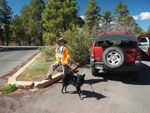
Hedy and Colter supported this hike with shuttle service and encouragement. For some reason I did not have my heart into this one. Perhaps because it was the last hike of the 4 major hikes I had blogged earlier about? Perhaps it was the difficulty of the hike? Perhaps it was the late start?
I refer to this hike as the Grapevine Route. Actually, in the hiking guides it is referred to as Grandview Point to South Kaibab Trailhead, which, to me, is a bit of a mouthful. Grapevine is the largest of the 3 named canyons I crossed over, hence the name.
April 18, 2016
Started late in the morning, around 9:30 or so. As I began winding my way down the Grandview Trail my pack felt heavy and the day hot. Several tourists asked where I was going and I briefly described my plan with the caveat that it all depended on water. I was carrying 3 liters and the guidebook recommended 3 gallons (each day). Oh well, more about that later.
About 10:45 I reached the Coconino Saddle and took a break there. I had been down the Grandview Trail a number of times before and was familiar with it to Horseshoe Mesa. The hike down to the Coconino Saddle is a stiff one. The topo map indicated 2 areas rated difficult but those were now behind me. The next section leading out to the mesa is categorized as moderate. I worked my way to the mesa and found the trail junction to Cottonwood Creek.

I had seen this sign on previous hikes but this would be the first time I would be exploring this trail. The hike down to Cottonwood Creek was a steep one with two sections of switchbacks. The immediate trail faded away in parts but could always be picked up by looking ahead. At Cottonwood Creek there was a water flow and I was able to drink heartily and replenish my water. It was quite hot and I had to plan for the 20 miles to the South Kaibob. If Grapevine did not have water I would have to retrace my steps back to Grandview Point. In any event, I was committed to camping out for the night. I continued to the junction with the Tonto East Trail and then to a spring about 1 mile beyond that where I set up camp. The spring had a seep of water but I didn’t need any.
April 19, 2016
Got an early start and worked my way over to Grapevine Creek, about a mile. I could look across the deep cut to the opposite side, about 1/2 mile. This was a point I would be hiking to after going deep into the Grapevine Creek Canyon, crossing to the west side and then coming back towards the Colorado-more than 5 miles to achieve a net distance of 1/2 mile. About a mile further I came across a spring with a water drip. I was able to replenish my water. While doing this I encountered a group of older men, about my age, and perhaps their sons or a boy scout patrol. They were from Connecticut and had started from Lonetree Canyon. They were heading to Hance Creek and would exit on the Tanner Trail. They informed me that Grapevine Creek had abundant flowing, clean water and that there was also water at Lonetree Canyon. Knowing that, I was assured I could arrive at the South Kaibob with a couple of liters of water which I thought would be plenty for getting out. I was now able to commit to completing the hike as planned-no retracing steps.

The trail continued for another ½ mile where it crossed over to the west side of Grapevine Creek Canyon. It is not a clear cross over and I had to carefully look for cairns, footprints, to guide me. This hike, of all my Grand Canyon hiking, was the best I had for route finding. I never strayed more than a 100 yards from the trail and was always able to quickly relocate it. Also, considering the steepness of the Grandview Trail and parts of the Tonto Trail I had not fallen once. These two successes were important because losing the trail and spending valuable minutes looking for it is exhausting, mentally and physically. Falling, of course, is something I want to avoid at all costs.
Once I had located the west side of the Tonto Trail I worked my way back to the Colorado River, then inland again to Boulder Creek Canyon where I set up camp for the second night. At Boulder Creek was a group of about 6 hikers heading east. They confirmed a good water supply at Lonetree Canyon.
April 20, 2016
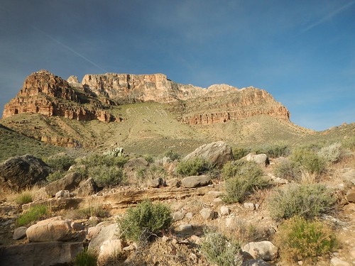
This day’s hike involved two steep scrambles (listed as DD on the topo map). The Tonto Trail does not normally involve steep climbing but in places involving a canyon the going can get a bit tricky.

Just after Cremation Creek Canyon there are two unnamed canyons each involving a steep scramble, vertical exposure and route finding once crossing to the opposite side. I camped in the second unnamed canyon where I found signage that marked the beginning of the day-use area, which I interpreted as no camping. It was just over a mile to the junction with the Kaibab Trail. I estimated that tomorrow’s hike would be about 6 miles and that I would arrive at the Kaibab with 2 liters of water. If I should need more there would be plenty of hikers on the Kaibab that I could get water from but didn’t feel it would come to that.
April 21, 2016
Unfortunately, the canyon never cooled during the night as it did on the previous two nights where I needed to wear my fleece. I slept on top of my sleeping bag, uncovered. I left camp at about 6:00 in the morning and arrived topside at 5:00 pm. Shockingly slow progress. About ½ mile an hour if you can imagine. The day was hot and the South Kaibab exposed.
I could see that I was going to be short on water. At Skeleton Point, about 3 miles from topside, a young man doing a day trip into the canyon engaged me in conversation and was very curious about where I had hiked in from. He had over 2 gallons of water with him and I asked him if he could spare a liter which he gladly did. This proved a godsend.
The sun was hot and with little shade. I did stop and take advantage of what shade there was. Some stops would be thirty to forty minutes. The time from 10:00 am to 4:00 pm is particularly dangerous and I could tell that I was dehydrated. I could only walk short distances and keep drinking water.
Looking back I can see now that I needed 6 liters of water when I junctioned with the South Kaibob. I have never carried that much water in my life but if I had to do it again I would take an empty gallon container and fill it at the last water opportunity in Lonetree Canyon. That would have taken me to the top without having to ask from other hikers.
Shortly before Cedar Ridge (1.4 miles from the top) a young couple gave me a 16 oz water and about ½ mile from the top another couple filled my liter body from their hydration pack. That took me to the top and I walked through the parking area, across HY 64, to the Jeep. Hedy was out walking with Colter but had left the Jeep open with a cold Diet Coke Caffeine Free-nectar of the gods.
