Section 3, Appalachian Trail
From: Hampton, Tennessee, 421.5 miles from Springer
To: Virginia 606, 601.6 miles from Springer
June 18, 2006 to July 2, 2006
Section 3 Miles: 180.1
For this section hike I began at Hampton, Tennessee and exited at Virginia 606. I had 14 hiking days, one zero day, and completed 180.1 miles. So, this was much improved from the previous year. For that reason I will theme this section Redemption. The mileage is staggering. When I was done I had only completed the first 600 miles from Springer Mountain. Thinking of completing 2200 miles was not wise.
A significant moment on the trail was entering Virginia and then Damascus. When I looked at a map of Virginia I realized I would be in this state for 4 years. The Va.–Tenn border is at the 459.3 mile marker and the Va–West Va border is at 996.2 marker. So that’s 536.9 miles. This was a sobering statistic because the hiking is hard and the progress incremental.
June 18, 2006
Hampton, Tennessee to spring 3 miles south of Iron Mountain Shelter
12.4 miles
433.9 miles from Springer
On the first day of my Section 3 hike I skirted Watauga Lake. Adrenalin flowing, I marched along at a brisk pace and crossed paths with an extraordinary couple who were southbound. We didn’t say a word to each other but the gentleman was an extraordinary physical specimen of the human race. He was carrying, easily, the largest pack I have ever seen in my life. His companion was a beauty to behold. I touched my cap as they walked by me. I continued on to the Wautaga Dam and took a break. Within minutes the couple joined me. They introduced themselves to me as Butterfly (the guy) and Monkey (the lady). They confessed that they had gotten “turned around” and were walking the wrong way. I would encounter Butterfly and Monkey for the next several days and, in fact, they were quite well known along the trail. During one of our encounters Butterfly asked me (ME!) for advice on what to carry in his pack. He wanted to eliminate some of the weight. He said that I looked like an experienced hiker who knew what was up. I must admit, my head swelled to about twice the size it normally is.
June 19, 2006
Spring 3 miles south of Iron Mountain Shelter to Low Gap at US 421
14.1 miles
448.0 miles from Springer
June 20, 2006
Low Gap at US 421 to Damascus, Virginia
15 miles
463.0 miles from Springer
June 21, 2006
Damascus to Whitetop Laurel Creek
14 miles
477.0 from Springer
June 22, 2006
Whitetop Laurel Creek to Thomas Knob Shelter
14 miles
491.0 miles from Springer
June 23, 2006
Thomas Knob Shelter to Fox Creek
12.7 miles
503.7 miles from Springer
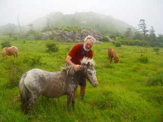
Encountered some beautiful wild ponies on this day. One of my best days on the AT. The ponies were friendly, could be approached and petted, and were beautiful. It was a wonderful experience to be able to do this.
June 24, 2006
Fox Creek to Dickey Gap near Troutdale
8.5 miles
512.2 miles from Springer
June 25, 2006
Dickey Gap to Va 16, Mt. Rogers National Recreation Area Office (Partnership Shelter)
14.5 miles
526.7 miles from Springer
I stayed at the Partnership Shelter and had a hot shower. Very strange shelter to provide such amenities. We had a large group gathered at the shelter and ordered pizza and beer from the local area and it was delivered to the gate of the Mount Rogers National Recreation Headquarters next to our shelter. Most of the folks there seemed to know each other. I picked up on some of the talk that they were thru-hikers and had seen each other on and off during this first 500 mile stretch of trail. All were pretty young. In 2006 I was 55 and these folks were in college for the most part. I did hike with them a bit after this but after a couple of days they had outdistanced me.
June 26, 2006
Mt. Rogers NRAO to Va 610
21 miles
547.7 miles from Springer
This was my longest distance for hiking in a single day. The terrain was gentle, the day was beautiful, and I had a wonderful lunch stop in Groseclose. After lunch I set off and hiked for about 10 more miles before I was stopped by oncoming darkness and rain. I had to stop where I was (just having crossed Va 610 and climbed an embankment on the opposite side). I found a place just off trail and quickly set up my tent and got my stuff out of the rain. I guzzled a liter of Power Aid and washed it down with a Baby Ruth. It was a great day.
June 27, 2006
Va 610 to Chestnut Knob Shelter
13.6 miles
561.3 miles from Springer
June 28, 2006
Chestnut Knob Shelter to Va 615, Laurel Creek
14.8 miles
576.1 miles from Springer
June 29, 2006
Va 615, Laurel Creek to US 52 near Bland
6.9 miles
583.0 miles from Springer
July 1, 2006
US 52 to Va 608, Lickskillet Hollow
13.3 miles
596.3 miles from Springer
July 2, 2006
Va 608 to Va 606
5.3 miles
601.6 miles from Springer
