South Bass Trail to Bass Beach, Serpentine and Ruby Canyons, Waldron Trail, Hermit Trail, Granite Rapids
Friday, March 10, 2006 to Sunday, March 19, 2006
This solo Grand Canyon adventure ratcheted up the level of hiking for me. Driving up from Phoenix I got caught in a snowstorm (blizzard) on Highway 180 North of Flagstaff near the White Buffalo tourist site. It was close to a white out as I would drive about 10-15 mph and watch the right shoulder as best I could. It didn’t last too long but had the heart racing for a while.
I hadn’t really planned on what I was going to do this time and for some reason the Bass Trail called me. In my Official guide to Hiking the Grand Canyon (Thybony, 1994) one of the first South Rim trails described is the South Bass Trail. The guide describes the route to the Trailhead
South Bass Trail begins about 31 miles west of Grand Canyon Village via Rowe Well Road and Forest Service Road 328. A Kaibab National Forest map is recommended to avoid becoming lost. Rough dirt roads leading to the trailhead may be impassable in wet weather. A four-wheel drive vehicle is recommended in the winter and spring and may be needed at other times. Deeply rutted sections require high clearance… There may be a fee collected for crossing the Havasupai Indian Reservation.
For some reason I got it in my mind that this was the hike I needed to take. Actually, this hike would define my Grand Canyon experiences for the next two years and probably beyond.
When I reached Tusayan, I checked into the Seven Mile Lodge, my favorite locale. They don’t take reservations and there has only been one occasion when the park was full that I have not been able to stay there.
After getting my room I headed to the Back Country offices to find out about a permit for the Bass trail hike. It began to snow again and by the time I reached the back country offices it was blowing snow and quite cold. As I entered the offices a gust of wind blew me into the room and I had to turn and slam shut the door behind me. I was able to get a permit for the Bass Trail hike although what I really wanted to do was go down the Bass Trail and then come out the Boucher Trail. But no permits were available for that type of hike. So I settled for a canyon exploratory of the Bass Trail and the Ruby and Slate areas.
To get to the trailhead, as mentioned in the quote above, required a shuttle driver. Through one of the local hotels I got the name and number of a driver and made arrangements to be picked up at 7:00 in the morning (March 11, a Saturday) at the Seven Mile Lodge. The driver was ______ Tacey (I forget the first name). He was prompt and delivered me at the South Bass trailhead about 9:00 am. The ride out was quite an adventure as it had snowed again in the night-about ankle deep. As he drove away from the trailhead the isolation set in almost immediately. I could hear the 4-wheeler grinding down Pasture Wash, the access road to the trailhead and I began to wonder if I was up to this. He was scheduled to pick me up 5 days later at 2:00 pm.
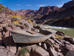
The first thing I did was attempt to take a photo of the trailhead. It was then that I realized, to my horror, that I did not have a flash card in my camera. Hence, no photos of this first excursion down the Bass. The photo to the right was taken April 23, 2013 by John and Jean Strother. I remember the abandoned boat and have never been back to this beach area to get my own photo. In any event, where the South Bass meets the Colorado River was my destination for the night.
I began gingerly making my way down the Bass. It was slippery. At one point my feet flew out from me and I poked my lower back with an agave spear. A bit further down the trail I did a whirling dervish over the side of the trail and did a few wild rolls with the backpack and arms flying, hat spinning off, hiking poles flipped in the air. As I laid breathing into the snow I tried to figure out if I was in one piece. Fortunately I was but when I slowly rose to my feet I realized that my pants were around my ankle. The trail had effectively pantsed me. It would certainly have been one of the most humiliating moments of my life but there was no one else there to see, so I let it go. I determined to take better care with the trail, a lesson I had been learning and relearning since I started doing sections of the Appalachian Trail—Don’t overestimate yourself and don’t underestimate the trail. Not taking a storage card for my camera was bad enough, but getting roughed up by the trail was pretty sobering. I was determined to do better.
This was my first experience using the GPS in field conditions and I had much to learn. With the initial settings it would show the top of the map in the direction I was hiking. This was quite disorienting for me although I am not certain why. It might be I have never been used to turning and facing the direction shown on a map-I never developed that skill. Also, I was getting off the South Bass trail and was relying too much on the GPS to find my way for me instead of using my eyes and common sense. At one point I found myself staring off at a rocky slope, no path evident, and lots of snow. I backtracked and looked for the trail. I would estimate that it took 45 minutes to find the correct pathway after backtracking several times. This would be a common theme for future hikes and a great thing to learn. The trails zig zag and if you don’t zig or zag, which is actually quite easy to do if you aren’t vigilant, you quickly find yourself facing a wilderness-and that can be discomfiting. The solution is to think—I missed a zig—and then backtrack and look for the zig. I’ve become much better at this now, but this was my first real experience with a wilderness trail and certain trail finding skills were required. I had to learn them quickly.
It took me the entire day to reach the Colorado. I camped on Bass Beach. I set up camp and then proceeded to cook my dinner—a Mountain House dinner, probably beef stroganoff. The previous night I had purchased water proof matches and a water proof container for them. Unfortunately, the matches needed the original box’s scratch surface (I guess) as I was not able to light a match. To my frustration I realized that if I didn’t meet up with someone down here (unlikely) then I would be eating cold and the Mountain House dinners might not even be edible. I don’t know how they would rehydrate with cold water, the instructions call for boiling water. So, this was another vital error in my preparation for the Grand Canyon wilderness trails. Never again would I hike without sure fire matches.
The next morning I hiked over to view Shinumo Rapids and vowed that I would someday return to get photos. From Shinumo Rapids I hiked over to Serpentine Canyon where I scared the dickens out of another hiker who was in the process of setting up a camp. We talked a bit. He was down for 6 more days and was scheduled to stay in Copper Canyon but had over estimated his abilities and so was setting up camp in Serpentine. That was the reason for him getting so scared when I came up behind him—he thought I was a park ranger that was going to do I don’t know what to folks who camp in the wrong places. Fortunately, this fellow had a couple of books of paper matches that he gave me. Wonderful luck for me.
I continued to Ruby Canyon where I set up camp. This canyon is extraordinarily beautiful, ruby-colored cliffs. In the morning huge snowflakes were drifting down. I hiked back to Serpentine Canyon and camped there. The next morning, on hiking the South Bass, I encountered a young man Ty Reidenbaugh. He was a medical student at Central Oklahoma University. He had hiked over from Hermit’s Rest which was the hike (in reverse) that I had hoped to do. In talking with him, despite the age difference, we found we had much in common. We were both surprised to find another individual in the canyon. He had no definitive plans for getting back to the Grand Canyon village so I mentioned that I had a shuttle driver picking me up the next day at 2:00 pm and after giving it considerable thought he decided it would be in his best interests to see if he could get a ride back on it. The alternative is a 30 mile hike over the plateau to Tusayan. He had made the same mistake I did when I hiked out Dripping Springs-no good plan for getting back to civilization. It was during our conversations and later with the shuttle driver that the idea of a Royal Arch Route hike was planted. And once it started to grow it simply wouldn’t be denied.
I still had a few days to explore the Grand Canyon. I used March 16, a Thursday, to dedicate myself to the Waldron Trail. I had passed the Waldron Trail junction several times now in my passages down the Hermit Trail. I decided to pack a lunch and use the entire day. I was not disappointed. March 17 and 18 I used to hike down the Hermit Trail to Granite Rapids, spend the night at the rapids and return the next day by the same route.
