Section 10, Appalachian Trail
From: Stony Brook Road (about 0.6 miles North of Stony Brook Shelter), 477.3 miles to Katahdin.
To: summit Mt. Washington, New Hampshire
June 30, 2013 to July 15, 2013
Section 10 miles: 145.4
This was my 10th year on the AT and it was my best year. Although I didn’t get the number of miles I wanted – 145.4 miles – they were hard earned and filled me with confidence. Without a doubt this was the toughest stretch of the AT to date and I expect more of the same for the next two years.
Here are my day to day notes—
June 30, 2013
Stony Brook Parking Area (Notown?)
Vt. 12
13.7 miles
Vermont, Section 3 of the AT
Hedy and I headquartered at White River Junction, on the Vermont side of the Connecticut River. We stayed at a Super 8 on Harland Road. It was economical and served all our needs for the few days we stayed in White River Junction.
Our starting point was an obscure parking area (a wide spot on a dirt road that would fit one car). This was a bad place to leave off my 2012 hike but it was with a purpose. This next stretch would be 13 miles and Hedy could pick me up at Vt. 12.
We were a bit concerned about finding the Stony Brook area as it is behind a maze of dirt roads and bridges. Fortunately, a road map of Vermont showed a location called Notown (this does not appear on the AT map. However, the New Hampshire-Vermont Appalachian Trail Guide identifies a Notown Clearing). Notown showed up on our Tom Tom and we were able to find Stony Brook easily.
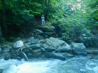
Stony Brook itself was running rapid and high. I was concerned about Hedy joining me like she likes to do for the first mile or so of the hike. We decided, because of the swiftly flowing Stony Brook, that Hedy would explore the AT going South, which she did for several miles before returning to the car. Of course I headed North and it was quite pleasing to realize that I was now logging actual AT miles after one year.
After several miles (crossed several logging roads) I arrived at Chateauguay Road and entered the Les Newell Wildlife Management Area. Late in the hike I arrived at an open ridge with a view of Mt. Ascutney.
I was suprised at finding my knees a bit weak. The day’s hike was not particulary difficult but being a year older and on the AT again the trail was reminding me that it was the boss.
July 1, 2013
Vt. 12
Patriots Bridge, White River, Vt. 14
12. 6 miles
Vermont, Section 2 of the AT
Hedy dropped me at Vt. 12 in the early morning and I began the planned 12.6 mile hike. The New Hampshire-Vermont Appalachian Trail guide describes this stretch as “a patchwork of wooded and cleared hills, ridges, and valleys.”
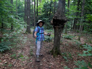
Hedy explored about the first mile or so of the AT while I went on ahead. At this stage of the big picture I am concerned about getting the miles and Hedy is concerned about the details of the hike, will stop often, turn rocks over, and constantly look for oddities of nature. I can’t do that.
At Dupius Hill (1730), about 5 miles into the hike, I had my first panoramic view. The AT doesn’t vary much in altitude. At Bunker Hill (1520) the AT begins to drop as it nears Vt. 14 (400). So, the hike was not strenous but it was quite long. I had estimated I would arrive at Tigertown parking area around 4:00 and was about 1 hour late. Hedy picked me up just after I crossed the White River on the Patriots Bridge (Iron Bridge) in West Hartford, Vermont. My intention was to reach the Tigertown Road parking area about ½ mile further north but there was a nice restaurant at the bridge crossing. Two hotdogs with sauerkraut and a cold beer that Hedy had for me completed the 2nd day. I was doing fine, on schedule, but I was limping noticeably, a bit, from the two days hiking. Fortunately the plan for the next day was a scaled back 10 mile hike. Tomorrow’s destination is New Hampshire so that will be quite an event for me.
July 2, 2013
Patriots Bridge, White River, Vt. 14
Connecticut River, Vt.-N.H State Line
9.3 miles
Vermont, Section 1 of the AT
Today I crossed into New Hampshire. It is always a big event to complete a state and begin a new adventure. It turns out that New Hampshire was very challenging. However, I wouldn’t hit the White Mountains wall for a few days yet. But they certainly were looming as the elephant in the room.
Hedy dropped me at my stopping point the previous day (the restaurant just north of the Patriots Bridge) and I followed the AT through West Hartford for about ½ mile to a parking area on Tigertown Road. Hedy joined me for the first bit and she explored a couple of miles of the AT from Vt. 14 northward.
The hike itself was on paved surfaces (both ends) with a bit of climbing in between. The forest was green from all the rain the area had been receiving. At Mosley Hill, near to Elm Street in Norwich, I chanced upon a small dog drinking water from the trail. I startled it and it began barking and backing up the trail. The poor creature had a collar but there was no way he/she would come to me. In short, the dog backed up the trail to Elm Street where somebody had left a blanket and a note that they were missing a dog. I found out later from a couple of hikers that the dog was reunited with its owners. Good news as I hate to see lost or abandoned animals.
I crossed through the streets of Norwich and then the bridge over the Connecticut River and into New Hampshire.
This was a pretty easy day for me. I was consciously trying to limit my hiking as I believe I over extended myself last year. In any event, this completed the final section of Vermont, section 1, on the AT.
July 3, 2013
Connecticut River, Vt.-N.H State Line
Etna-Hanover Center Rd.
6.4 miles
New Hampshire, Section 9 of the AT
Hedy was a bit surprised to learn I was only going to attempt 6 miles. But, when looking at the map, this section of the AT goes all the way to the Lyme-Dorchester Road, 18.1 miles. Based on my new regimen of reining myself in a bit I felt that doing this section in 2 parts would be wise. By exiting at the 6.4 mile mark (Hanover Center Road) I would be able to be plucked from the trail and not have to camp out for the night. And that pretty much established our pattern for this year’s AT experience-manage the miles and reduce camping out.
The Connecticut River is at an altitude of 400 feet. This section goes through downtown Hanover. Eventually I reached a soccer field where the AT enters the forest. The hike passed through pasture, grassland, and bogs. There was a bit of rain, just like every day so far. When the rain stopped the humidity was oppresive, like a jungle. Lots of vegetation, water, and sunlight. Hedy met me near the end of the hike at the Hanover Center Road (845 feet). We were able to enjoy a lunch at Isabelle’s Cafe in Thetford, Vermont. Afterwards, we scouted out the next pick-up point-The Lyme-Dorchester Rd. and had a relaxing afternoon.
July 4, 2013
Etna-Hanover Center Rd.
Dartmouth Skiway, Lyme-Dorchester Rd.
11.7 miles
New Hampshire, Section 9 of the AT
This hike completed the 18.1 mile section 9 of the AT in New Hampshire. This section crosses over the south peak (2290) and the north peak (2300) of Moose Mountain. The exit point, Lyme-Dorchester Rd. is 880 feet.
Shortly into the hike I came across a porcupine waddling down the trail. That’s always a good sign to see wildlife. At Moose Mountain I came across a local hiking her labrador Kelsie. The dog appeared to be having the best time of its life. This section has pastures, field, bogs and forest. Many wildflowers.
July 5, 2013
Dartmouth Skiway, Lyme-Dorchester Rd.
N.H. 25A
16 miles
New Hampshire, Section 8 of the AT
This was a long section hike for me. At the time I didn’t realize that I would not be able to hike 16 miles in one day anymore. I was quickly approaching the Whites and when I did reach them I would hit a wall. Looking back I can see it. But on July 5, 2013 the Whites were just the elephant in the room. I had no idea what I would encounter.
On this day I crossed over two mountains-Smarts Mountain (3230) and Mount Cube (2909). The exit point at N.H. 25A has an altitude of 900 feet.
The section hike involved scrambling over two ledges-Lambert Ridge and the Eastman Ledges. The first goal of the hike was Smarts Mountain. It is marked by a firetower that was visible from the Lambert Ridges. At the Lambert Ridges I encountered a father hiking with his son and daughter. They were planning on doing the AT in New Hampshire. The young boy pointed across the valley to the firetower, barely visible, and asked if that was where we were hiking to. It was, and it was interesting to see the course our trail was taking us. I would leapfrog with these folks for the next couple of days.
At the firetower I encounter 3 hikers and a young boy, the son of one of the hikers. In our conversation I found out that one of them had just completed a hike through the White Mountains. He showed me the marks on his legs from the spills he took and told me a few hiker stories about things to be careful about. Water was an issue-be sure to have enough water. And once again, the Whites are looming before me.
I continued on to the Eastman ledges and then Mount Cube. I phoned Sophi from Mount Cube and left a message for mom since we weren’t connecting with our cells. I was still 2 to 2 ½ hours from the pick up point, N.H. 25A and would be at least an hour late meeting Hedy. Just didn’t want her to worry.
Hedy was waiting for me and we headed for Lincoln, New Hampshire. Our new HQ would be the Kancamagus Motor Lodge. The 16 miles were rough on me but I still had one more day before I would hit the wall.
July 6, 2013
N.H. 25A
N.H. 25
9.7 miles
New Hampshire, Section 7 of the AT
This day’s hike corresonded to section 7 of New Hampshire as listed in the Appalachian Trail Guide for New Hampshire-Vermont. Significant trail points are Mount Mist (2220) and Ore Hill (1866). The AT crosses N.H. 25 (900) about ½ mile north of Glencliff. At the summit of Ore Hill I entered the White Mountain National Forest. Something big was going to happen.
Hedy met me about 1 mile from N.H. 25. We spent the afternoon scouting out the next pickup point at Kinsman Notch, about 5 miles from Lincoln where we were staying. Our HQ was nicely located as I would be hiking along a huge arc north of Lincoln for the next week.
July 7, 2013
N.H. 25
N.H. 112 Kinsman Notch
9.5 miles
New Hampshire, Section 6 of the AT
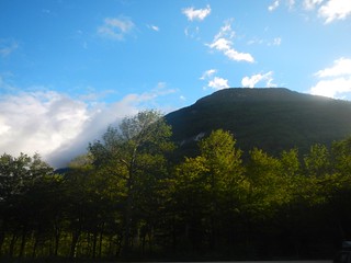
This day’s hike marked my first venture above the tree line. Mount Moosilauke (south peak 4460, north peak 4802) is referred to as the “gentle giant”. I think that name comes from the south side approach, certainly not the northside as I was to find out.
Hedy dropped me at N.H. 25 and since I had scouted out where the trail continued northbound the day before you can imagine my surprise when after hiking all of 10 or 15 yards I came to a steep cliff bank along Oliverian Brook. After scouting out the area for 10 minutes or so I found a decent place to ford the brook and then picked up the Town Line Trail. The trail enters pastureland that leads to the base of Mount Moosilauke. Pastureland is enjoyable to walk through. It usually is pretty level, easy hiking with abundant flora. However, according to my Appalachian Trail Thru-Hikers’ Companion-2009 this was the last pasture walk I would have on the AT. Between this point and Katahdin-no more pasture walks. This was a bit sobering as the game plan has changed. In fact, you could say that I hit the wall even though I was not yet aware of it.
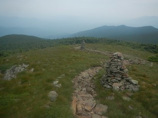
The hike up Moosilauke was shrouded in clouds and a light rain persisted throughout the morning. But, just at the point where I was breaking through the treeline it began to clear. The ridge line is exposed and views are on both sides. The trail is marked with huge cairns and between peaks follows the Moosilauke Carraige Road which predates the AT by quite a few years. It is almost surreal walking among the cairns and the mist.
From the summit the Beaver Brook Trail leads downwards to N.H. 112. About a mile and a half from the exit point I hit a treacherous section of the AT. It had been raining throughout the day so there was plenty of standing water and slippery rocks-just like all the previous days to date. However, near the Beaver Brook shelter the trail takes a turn for the worse. The AT parallels Beaver Brook as it makes a steep descent. The trail gets so steep in some parts that the trail maintainers have bolted wooden steps into portions of it. Otherwise I’m not sure how it would be possible to get off Moosilauke. Still, just getting to the steps, which were wet and slippery themselves, was a bit of an adventure. There are plenty of places to make a misstep.
While struggling my way down Beaver Brook I happened across two separate young families. Each had a young daughter (maybe 5 or 6) hiking up Beaver Brook. I have no idea how far up they were going but was incredulous at bringing your young children out to such a rugged section.
This was my first experience with the Whites. I got a taste of some of the difficulties in hiking in the Whites but I also began to realize that the populace of New Hampshire is different. This state is filled with hiking enthusiasts (see paragraph above re young families). Above the tree line on the Moosilauke Carraige Road I encountered more people on the AT then ever before. This was the way it was going to be for the rest of the week I had on the trail. Half a dozen people I would come to meet would describe their adventures hiking in the Whites. One man, about my age, that I encountered on the Moosilauke Carraige Road described an adventure he had last May 25. He was in this same spot and caught in a blizzard. He submitted video to the Weather Channel who published it, although I could never verify this. Others were part of a club called the New Hampshire 4000 footers. These folks were dedicated to hiking all of the peaks in New Hampshire above 4000 feet. See list.
Over the next few days I would come across many trails. The AT would actually lose its identity at times as it was “taken over” by a local trail. I began to get a bit testy about New Hampshire insisting on using their local trail names instead of the AT. It wasn’t until later when I read Not Without Peril, that I realized that the local trails have been around much longer than the AT. I now understand why the local names are so important as they are attached to many local historical events. They have precedence.
I arrived at N.H. 112 (1870 feet) thankful to be alive. Seriously, the Beaver Brook section is one that I would never want to repeat. It is a killer. What would the rest of the Whites have in store?
Hedy and I scouted the next pickup point-Franconia Notch. We found a parking lot after a bit of searching and inquiry, where a spur to the AT is found. This next section would involve my first overnight of the year. No more daily pickups for the remainder of our stay.
July 8, 2013
N.H. 112 Kinsman Notch
Eliza Brook Shelter
7.5 miles
New Hampshire, Section 5 of the AT
New Hampshire section 5 is 16.3 miles. I knew from my experience hiking the Lyme-Dorchester Rd. to N.H. 25A (section 8, 16 miles) how exhausting a hike of that length could be. And this would be in the Whites. No way should I attempt to do this section in one day and it was a good decision.
At the 7.5 mile mark is the Eliza Brook Shelter. That would leave about 9 miles for the second day. I should “easily” be able to handle that.
As it turned out Hedy dropped me N.H. 112 with a light rain falling. I began to climb (Kinsman Ridge Trail is the local name) to the junction with the Dilly Trail (2650 feet). I reached the shelter in the early afternoon and contemplated proceeded on but decided to stick to my plan. The hike to this point was not bad at all but I had no idea how the remainder of this section would play out or if I could find an appropriate tent site. As it turned out, the next day would prove to be my most arduous day hiking on the AT. I’m talking about 1796.8 miles of AT trail behind me with the next 8 miles ahead of me waiting to eat me alive.
The shelter filled to capacity. The rain continued to fall, sometimes heavily. A latecomer arrived about 9:00. He was a local who had hiked over from Garfield. Garfield is a shelter in the Whites 20 miles north. We were incredulous. How could somebody hike 20 miles in a single day across this type of country? His goal was to get to Hanover by Thursday where he was to play in a soccer game. Incredible.
During this section hike I managed only 1 audio recording.
OK, it’s, um, 2:27 PM. It’s July 8th. I’m holed up at the Elizabeth (sic) Brook Shelter. Um, I had a real tough slog up to here from Highway 112. It’s only (hic) about 7.5 miles but very difficult terrain. And I stopped at the shelter because it started to rain. You might be able to hear the rain pattering on the roof here. I was going to go up another 4 miles and the caretaker of the cabin, a young guy here, was telling me that the next 4 miles is considered to be by many people the toughest section of the Appalachian Trail and uh that uh probably a good idea that I just break here, cause I was going to on on if it wasn’t raining. But the rain really made up my mind for me. And so I’ve got a tough hike out tomorrow. I can see that. Now when I say tough hike I mean it is rugged country, it is steep, it is slippery, it is not conducive to safety, um, you have to be on your toes at all times. They put in all kinds of handholds and helps to…on the very steep areas but yet it is still very slippery and, um, steep. Anyway, that’s where I am right now. This is in the White Mountains area, just north of Lincoln, New Hampshire where we are staying. We started in Vermont, um, at Stony Brook right where we left off. The Tom Tom in our car took us right up to the start off point and I made 13 miles the first day and another 13 the next day and was feeling pretty good but my legs were pretty worn our from those two hikes. But, um, I haven’t missed any days, I made progress every day and its been excellent. Um, right now the progress though has slowed considerably and, uh, that’s just the way it is. I’ll just do my best to get through this and see how many miles I can get before, um, we have to return on the 15th. I’ll sign off for now.
July 9, 2013
Eliza Brook Shelter
I-93, U.S. 3, Franconia Notch
8.8 miles
New Hampshire, Section 5 of the AT

Hardest day on the trail, ever. I certainly will never forget. I was the first person out of the shelter. After crossing Eliza Brook (2400 feet) I made my way through marshland in a light rain. I was soaked in short order. My hiking shoes were pretty well ruined in the previous day’s hike and they were now proving themselves to be a liability. But I had to have hiking shoes and I wasn’t going to get dry anytime soon. So the slog continued to South Kinsman Mountain.
Shortly after reaching Harrington Pond (3400 feet) I began a rock scramble. There was no longer a trail and for the next 3-4 miles there were only blazes. It was a rock scramble mixed with a marsh walk. Just past the South Kinsman Mountain another hiker from the shelter had caught up with me-trail name Paranoia. Very nice fellow and obviously a seasoned hiker. We leaped frog on the trail to the North Kinsman Mountain. On the downside, the Cascade Brook becomes the trail for a 100 yards or so. I was due for a break and I spotted an off-trail area and worked my way over to it. In the process I slipped and wedged my foot between two rocks and couldn’t get it out. Of course, Paranoia shows up and wants to know if there’s a problem. And of course, while I’m untying my soggy boot so I can get my foot out I reply-”No, no problem”. Awkward moment.
I fell 5 times this day. These were flat out slipping-on- steep-rocky-slopes-bruising-thighs and shins type of falls. On one of the falls I jammed my Leike into the earth and used it for leverage. The pole popped in two. This was a Leike set that I have used since the start of the AT, having ordered it from LL Bean by the internet. These poles had been with me for countless walks into the Grand Canyon and now, at the 1,800 mile mark this one popped on me.
I am too old to be falling. This day was horrendous. And what was frustrating, I only had to cover 8.8 miles to get to the pickup point. By the afternoon I began to wonder if this would even be possible. So, the going was rather slow and my confidence level was way down. The going was difficult, the worst I’ve experienced, and my equipment was breaking down. On top of that, my rain cover went missing. Somewhere in a rock and brush scramble it must have been swept from my pack. I never understood the concept of that rain cover. When I purchased my pack it was the recommended cover. It was super because it was almost without weight and packed up to the size of a handkerchief. But it never really matched up with the pack and could work its way loose.
My pack began to give me problems. It is a Northface, 40 liter pack that I have had for about 7 years. The chest strap separated from the pack and could not be reset. I had a hard look at the pack during break and decided it was time to retire it. It was basically rotting away in the New Hampshire rain.
I arrived at the Lonesome Lake Hut around noon-a large structure smack on the trail. This was my first encounter with a hut. The hut system is unique to New Hampshire. I found them to be nothing more than a very expensive shelter with a dining room. The huts are owned and maintained by the Appalachian Mountain Club (AMC). They are expensive to stay at and are quite popular with the locals.
New Hampshire is filled with outdoor enthusiasts. I would encounter more hikers on the AT in New Hampshire then at any other part of the AT in any other state. And the interesting thing to me, the local hikers never seemed to think of themselves as being on the AT. They were always on a local trail that, in part, would coincide with the AT. That was when I began to realize why the trail names were using local names so predominately-these trails had been around long before the AT existed.
I stopped in at the Lonesome Lake Hut and ordered a soup (horrible, thinly-brothed pumpkin soup). There were a few pastries available, none of them very good. I found out that everything is made from scratch at the huts and the “croo” prides themselves on that. The “croo” is comprised of young college kids who are outdoor enthusiasts. I think their food products were created with enthusiasm but were not very good to eat and downright expensive ($1 for a small glass of tepid lemonade, $2 for a crusty scone for example). The “croo” were very friendly and accomodating. They have a tough job. I do not know what they are paid but the hours worked have got to be killers. Consider this blurb from an online newspaper-
… the job pays just $7.35 an hour, yet requires slogging hundreds of miles uphill and downhill all summer while carrying 40 pounds of supplies on your back, then getting up at 5:30 a.m. to cook and clean. (http://www.nashuatelegraph.com/livinglifestyles/920260-224/da-croo-is-an-exclusive-but-desirable.html)
From Lonesome Lake Hut to Interstate 93 was a welcome easing of the terrain. Unfortunately, just out of Lonesome Lake Hut I slipped and fell to my knees. I hate it when I do that. There was no reason for slipping, no wet rocks, no steep pebbly ledges, just a trail and a loss of focus.
I arrived at the parking area around 2:45, wet, bedraggled, generally banged up. Hedy had been waiting for a couple of hours. I was in pretty bad shape-water logged feet, bruised shins and thighs, utterly exhausted from the day’s adventure. My equipment was in a shambles. I decided I had to do better.
Hedy had moved our headquarters from the The Kancamagus Lodge to a cottage at the White Mountain Motel. Hedy really wanted to get a cottage and this looked like a great place. Unfortunately, the bed was so bad for Hedy that she could not sleep. So, the stay at the White Mountain Motel was limited to just a couple of days. Hedy scouted out another HQ in Twin Mountain, NH.
July 10, 2013
Zero day. I don’t like taking zero days because time is short when I’m on the AT. It is important to me to always advance, even if it is less than 10 miles-and I was having plenty of those short advances this year. But, it is really easy to know when you need to have a zero day. Utter exhaustion is one indication. Essential equipment needs are another. I had both.
Hedy was able to purchase socks for me at the Lahout’s Summit Shop in Lincoln, NH. She was also able to get my broken Leike repaired, for free. A Lahout’s employee found a replacement section that matched my pole and that instantly took care of a huge concern.
In her wanderings Hedy had spent some time in Littleton New Hampshire and had seen some great pack selections there. We headed out to Littleton, a beautiful little community, and went to the Lahout’s outfitter there. The store was empty, the employee knowledgeable, and we quickly selected a Deuter pack, 38L.
July 11, 2013
I-93, U.S. 3, Franconia Notch
Garfield Ridge Shelter
10.3 miles
New Hampshire, Section 4 of the AT

I was not entering the day with a lot of confidence. Section 4 of the AT in New Hampshire is 27.7 miles. Based on my July 9 hike this was daunting. I had no idea how difficult the trail was going to be, only that it would be difficult. My plan was to complete this section in 3 days. I would tent at Garfield Shelter and then stay at the New Zealand Hut. I had a reservation in for that and considered it to be my safety net.
I worked with my new pack and modified my thinking of how I was stowing items. In the process, I was able to combine the cooking apparatus with the food. The medical kit I reduced in size and went with a gallon zip-lock bag. The Deuter packed beautifully and it had a built-in rain cover that was easy to secure. I’m not sure why this isn’t a standard feature on all packs. It really made it easy to protect the pack with no chance of the cover coming unattached.
My feet were in fair condition after the zero day. Hedy worked hard to save my Keen hiking shoes and she did. We dried them thoroughly with a hair dryer. Hedy removed the linings and ran them through a drier. We had some waterproofing that she liberally applied. However, at some point in the eve of the hike, I decided to go with my hiking sandals. I had used them before whenever I had a blister or foot issue and I thought it would be best to use them and not go with the hiking shoes for this section. My trail sandals have at least 500 AT miles on them and I felt pretty confident wearing them. They provided further relief to my feet while allowing me to continue hiking.
Garfield Shelter was 9.7 miles from Franconia Notch. To save some time (about 1 mile on the Whitehouse Trail), Hedy dropped me at the point where the AT crosses under a bridge at Interstate 93. It was 6:30 AM. I picked up the AT under the bridge and followed the Pemigewassat River to the Liberty Spring Trail (local name coinciding with the AT). I had saved 45 minutes by not having to walk the spur trail to the AT. The weather was fairly clear and I was well equipped with my confidence level rising a bit. I began the first day of the 27.7 mile section.
The Liberty Spring Trail is straight uphill to Mount Liberty (4260 feet, 0.3 spur trail to summit) and then Little Haystack Mountain (5089 feet). About 1 hour into the hike it began to rain lightly. In a few minutes it turned to a drenching rain. My decision to wear sandals was paying off early. My feet would easily dry out once the rain stopped.
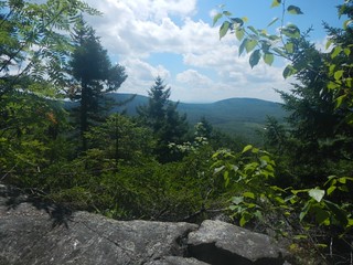
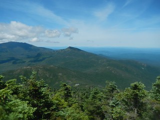
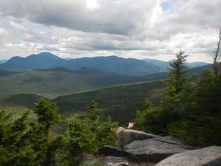
As I climbed to Little Haystack I watched the water stream from my hat. But, on the approach to Little Haystack the weather broke. I was above treeline and it was surreal with 360 degee views, rolling mists, rocky cairns. This was the beginning of a 2.5 mile walk along the ridgeline.
In spite of the blows to my confidence, the difficulty of the hiking, New Hampshire was becoming, by far, my best experience on the AT. The ridgeline views as I made my way to Mount Lafayette are something I can not get out of my mind. From Mount Lafayette I had a clear view of Mount Garfield, my stopping point for the day.
I arrived at the Garfield Ridge Shelter at 6:30. That means that it took me 12 hours to hike 9.8 miles. That is slow going but that is also the nature of the trail in the Whites. My day’s progress was very positive, my equipment was nice and dry, and my spirits were high as I set up my tent.
Throughout the day I began leap frogging with some other hikers. Most notably were a father/son (father being at least my age I would guess) I encountered at Mount Lafayette. The father was impatient to get to Mount Guyot, there day’s destination and they took off. I didn’t expect to see them again but they stopped at Garfield as the trail was just too difficult to make Guyot. They were AT through-hikers and were used to doing 18 to 22 miles a day. That’s an extraordinarily long day for me. Twenty miles or more would certainly ruin me for the following day. But for through-hikers that’s pretty normal. However, things change in the Whites and one must scale back daily mileage expectations. I did learn that I can make 10 miles a day in this terrain. So, I’ll be OK.
Another gentleman I met was Just John. He was a year younger then me and doing the exact same thing-hiking the AT by sections. He had a nine year hiatus in his hike at some point because of the economy and how it affected his home life. But he was retired, kids all moved from home, and he was back on the trail. We would continue to cross paths for the next two days.
July 12, 2013
Garfield Ridge Shelter
Zealand Falls Hut
9.7 miles
New Hampshire, Section 4 of the AT
The Zealand Falls Hut was my safety destination for this section. I had no idea how well I would fare on this section based on my experience July 9 when I hiked into Franconia Notch.
In the early morning I broke camp and set out at 6:15. I would arrive at the Zealand Falls Hut at about 5:45 pm, just before dinner was served.
The AT, leaving the Garfield tentsite going north, descends down a wet precipice marked with white blazes. This was a short, terrifying section of the trail. After having fallen down so many times in previous days I approached this descent with total focus and caution. After this difficult descent the trail levels off for a couple of miles. I arrived at the Garfield Hut at about 9:15 am and had a bowl of soup. How hard is it to prepare soup? A “croo” member fussed over it for about 10 minutes and then served it to me cold.
By midday I had arrived at the summit of South Twin Mountain (4902 feet) and worked my way across the ridgeline toward Mount Guyot. About 1:00 pm I reached the junction of the short spur trail leading to Mount Guyot. The weather was excellent. Bright sun and blue skys. I continued to Zealand Mountain (4250 feet).
Thus began a series of careless falls. Unlike the previous falls these were pretty harmless but were troubling because they were caused by a lack of focus. The worst fall (most embarassing) was a tenth of a mile from the Zealand Falls Hut where I crossed the Whitewall Brook. This is a swiftly moving brook over a smooth rock structure so it was pretty obvious this would be a slippery undertaking. I didn’t stand a chance. Making my way down the bank I actually slid into the brook. This was a pretty good soaking but fortunately the pack and rain cover did their job. I stumbled into the Zealand Falls Hut fifteen minutes before dinner was served.
This was my first experience staying in a hut. As I mentioned earlier this was a precaution I took because I was unsure how well I would fair along this 27.7 mile stretch of the AT. The hut experience is not to my liking. It was crowded with outdoor enthusiasts which is not a bad thing. I just don’t do well in large groups of strangers. The food was extremely mediocre. I don’t think it was from lack of trying but more from a lack of experience. I realize I was only there for one dinner but from my dropins at other huts for water, soup, or a snack I was under the impression that the young kids operating the huts were trying too hard-making their menus too ambitious. Also, I don’t really think they made wise menu choices. For example, soup for dinner was mushroom. I love mushroom soup but many people do not eat mushrooms. About half of the table passed on the soup. I thought-great, more for me. But the serving I got was a thin broth with a bit of onion floating around-no discernable mushrooms. I think they all sunk to the bottom. The entree was some kind of Italian chicken preparation. Once again, ambitious menu but not a very good end product.
I was the last one to get a bunk and the “croo” had to search it out for me. Finally the single vacant spot (Zealand Falls Hut holds 36 in 4 co-ed bunkrooms) was found. I will conclude this description of my hut experience by stating that these are over-priced cash cows. Now I can’t really be sure of that but I dropped about $125 to have a safe haven. As it turns out I would have been much happier tenting it but I didn’t know that when I made the plans for doing this section. I hope I never have to stay at a hut again. Or a shelter for that matter.
July 13, 2013
Zealand Falls Hut
U.S. 302, Crawford Notch
7.7 miles
New Hampshire, Section 4 of the AT
This was the final stretch of section 4. The AT descends gradually from Zealand Falls Hut to US 302. Near Ethan Pond is a large boggy area. Plenty of board walking through a sloppy landscape. I arrived at U. S. 302 around 11:00, well ahead of schedule. I had asked Hedy to be there around 4:00 so I had plenty of time to reflect on section 4 and the remaining two days I had left to me. When I began section 4 there was some doubt in my mind about being able to continue past U.S. 302. Now, there was no doubt in my mind that I would be continuing the next day to Mizpah Spring Hut area and then on to Mount Washington on my final day. The prospect of hiking to Mount Washington was exciting. It had been the elephant in the room for a long time and now I was finally going to be able to deal with it.
My hiking sandals served their purpose, once again. I received a few comments from fellow hikers as to the efficacy of hiking in sandals and I assured them I had done it before, several times, with success. I was hoping that the final two days I could return to my hiking shoes though, which I am most comfortable in.
The weather had broken finally. After 2 weeks of daily rains alternating with sunshine, the last 2 days had been clear with more forecast for the future. My hike to Mount Washington appeared to be perfectly timed.
My final two days are not agressive at all. The Mizpah Hut area is only 6.4 miles and from there to Mount Washington is 6.1 miles. It is all climbing though.
Hedy arrived an hour early, thankfully, and we took off to our new headquarters in Twin Mountain, New Hampshire. She had found a kitchen and room at a reasonable rate
July 14, 2013
U.S. 302, Crawford Notch
Mizpah Spring Hut
6.4 miles
New Hampshire, Section 3 of the AT
Hedy joined me for the first 1.5 miles of a fairly steep ascent. We crossed U.S. 302 and picked up the Webster Cliff Trail, the local trail that coincides with the AT. About the 2 mile mark the trail breaks out to the Webster Cliffs with views down below to U.S. 302 and the state park buildings.
At 3.3 miles I summited Mount Webster (3910 feet) and at 4.7 miles the summit of Mount Jackson (4052 feet). From Mount Jackson it was pretty much a contour walk to the Mizpah Spring Hut. I arrived quite early (1:40 pm) and staked out an isolated spot at the Nauman tent site. The site filled up in a few hours and the site nearest to mine was actually quite noisy. Not obnoxious but just a family making family talk. I walked over to the Mizpah Spring Hut and picked up some earplugs and a book from their library Not Without Peril by Nicholas Howe. This turned out to be a great way to spend the afternoon-absorbed in this fascinating book that factually details 150 years of history on the Presidential Range. Most of the book is centered on Mount Washington. Reading this book helped me to understand the New Hampshire phenomenon of having many outdoor enthusiasts and appreciate the area I was hiking through. Most people I had encountered on the AT were not through-hikers-they were local hikers, some of them participating in the 4000 foot club.
July 15, 2013
Mizpah Spring Hut
Mt. Washington
6.1 miles
New Hampshire, Section 3 of the AT
My last day on the AT for 2013. I was going to be well short of the distance I needed to complete this in two more years. I would finish this day wishing I had at least 4 days more to get out of the Whites and into Maine. I was making progress every day, albeit not a lot of mileage. Each day in the Whites was challenging yet rewarding. My confidence had returned after taking a blow at Beaver Brook. Hedy and I were working together very well to find pickup points, HQs, and resupply. This day she would take the auto road to the Mount Washington summit which is a bit of an adventure in itself.
I got an early start (5:45) and crossed Mount Clinton (4312) about 50 minutes later. I picked up the Crawford Path trail and this would take me all the way to Mount Washington. Once again, Crawford Path and AT coincide but the local name rules. At first that fact irritated me but now I realized there were more locals hiking the trail then AT hikers.
The Crawford Path led me past Mount Eisenhower (4475 feet) and Mount Franklin (5001 feet). That left Mount Monroe (5372 feet) before reaching Lakes of the Clouds Hut. Each of these mounts can be summited by following a spur trail from the Crawford Path. I was hiking the ridge line at about 5000 feet.
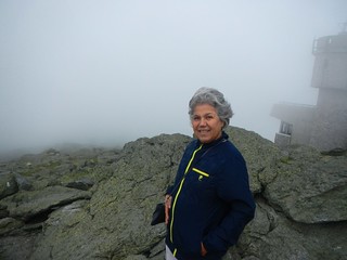
The final 1.4 miles led me to the Mount Washington summit. This final stretch passes by Lakes of the Clouds and then enters a bare, boulder strewn approach. Mount Washington was covered with clouds but occasionally would clear enough to see the large radio tower. Seeing that, I knew that I was close. Going from the Lakes of the Clouds Hut to Mount Washington is dangerous depending on the weather but I was walking in fine weather. I was a bit surprised at the summit to see the heavy tourist traffic. The auto road brings in a lot of folks and the summit has a restaurant, a museum, a rail station, and view points. It was surprising to see tourists in flip flops, casually walking around, eating and shopping. Sort of a culture shock coming in from the trail but that’s OK. I had reached the summit of Mount Washington, my stopping point for this 10th year on the AT. It was an enormously satisfying experience, this 10th year. I am looking forward to returning to the summit of Mount Washington next July and then getting the heck out of the Whites.
