Section 11, Appalachian Trail
From: Mt. Washington, New Hampshire, 332.5 miles to Katahdin
To: Caratunk, Maine, 151.3 miles to Katahdin
June 26, 2014 to July 17, 2014
Section 11 miles: 181.2
[Selected photos from Vivian and Hedy—New Hampshire and Maine 2014]
This section hike began June 25 when Hedy and I boarded a SouthWest Airline for Portland, Maine. We rented a car in Portland and set the GPS for Berlin, N. H. We arrived near Berlin in the afternoon but realized we were better off staying in Gorham. And that is where we established our first HQ-Gorham, New Hampshire in the Gorham Motor Inn. This turned out to be ideal for us because of location and we were HQ’d out of Gorham until July 5. Hedy supported me throughout, enabling me to get off the trail whenever it was convenient. We spent time scouting pickup and drop off points and this has really helped me the last several years. It has enabled me to do some day hiking as well. Vivian and Andrew joined us July 8 and the three of them were able to explore the Maine Countryside and take a trip to the summit of Mount Washington in New Hampshire.
Here is a synopsis of the hike—
6-26 to 6-27, 2014
Mt. Washington to Pinkham Notch
13.5 miles

I had thought about this hike for an entire year. Poring over the maps and thinking back to last year’s progress, I had pretty much convinced myself that, on this first day, I would probably make it to Pinkham Notch, give Hedy a call, and sleep in a bed. I quickly learned that wasn’t going to be the case. Mount Washington has a surface akin to what I imagine the moon is like. I picked my way over and through large, volcanic rocks from the very get go—the Trinity Heights Connector.
Somewhere, around midday, I slipped and in the process gripped my left pole so hard that I heard a snap. I had just broken my little finger (left hand) but wouldn’t know that until later in the hike.
I didn’t come close to Pinkham Notch. I didn’t even make it to the Osgood Campsite. I did reach Madison Spring Hut about 3:00 in the afternoon and pushed on over Mount Madison, determined to reach the Osgood Campsite. But, it was not to be. Somewhere I became disoriented. This is one of a few places where the AT bends around and heads south even though you are northbound. I retraced my steps, unknowingly, for about 20 minutes before I picked up the error on my GPS. Its always embarrassing when I find myself doing this—it is disturbing and tiring. I was on my first day out and had just added, at the very least, an extra mile of rough hiking.
Now I was focused and careful to watch the blazes, my map, and GPS and was able to reach the treeline about 6:00. Just inside the treeline was a perfect camping spot. I was still short of the Osgood Campsite but this was ideal. My plan was to get an early start in the morning.
The next morning I set out early and had an exceptionally steep descent to the Osgood Campsite area (about 1 to 1.5 miles) where the trail calmed down a bit. I arrived in Pinkham Notch about 2:00 pm.
6-28 to 6-30, 2014
Pinkham Notch to U. S. 2
21.1 miles
The next morning I set out for Carter Notch. Hedy and I got information from the Pinkham Notch folks so I had a good idea of where to find a campsite since none were listed. Hedy joined me for a bit as we started out on the Lost Pond Trail. Just before the assent up Wildcat Mountain there was a side trail to highway 16. We followed that for a short bit and hit the Ellis River where Hedy bravely forded the river to get to the Highway and a walk back to the car.
Wildcat Mountain was extreme hiking-just as bad as the previous day’s and it was going to be like this for the remainder of the section hike I came to find out. Around noon I reached the Wildcat Ski Area Gondola where many tourists were lounging about, picnicking, taking photos. I joined them.
I continued over a series of Wildcat peaks and in the early evening arrived at the junction of Nineteen-Mile Brook Trail. There were several excellent sites for camping and this is where I stayed June 28.
Early in the morning I hiked into the Carter Notch hut and replenished my water and bought some Snickers. I met some other section hikers there—KiYa, Yoda, and MOR. I must admit, KiYa was very cool. All three could kick butt on the AT. I set off before them and met them one last time at the summit of Carter Dome. They were completing the AT and this was their 5th year.
I continued to Mount Hight and in the early evening camped at Imp Campsite. The next day I arrived at US 2 about 2:00.
7-1 to 7-3, 2014
U. S. 2 to Grafton Notch
31 miles
This section was unusually difficult and at the same time built my confidence that sustained me for the remainder of the hike. My trail book The Official Appalachian Trail Guide to Maine recommends 3 to 5 days for this section. I told Hedy to plan on 5 because I am slow. It took me 3 days. Fantastic! My first day Hedy started with me for about a mile and then I began the assent up Mount Hayes. I pushed on to the Gentian Pond Campsite and arrived there in the near darkness. But that was over 12 miles of difficult terrain. I phoned Hedy and told here to plan on meeting me at Grafton Notch on the third. That would be two 9 mile hikes.
The following day I climbed Mount Success and around noon hit the New Hampshire-Maine State Line. Very momentous occasion. I was now hiking in my final state. The remainder of the day involved some difficult hiking up Mount Carlo and Goose Eye. I arrived at the Full Goose Campsite in a drizzle. Fortunately it only lasted 30 minutes or so.

The final day was my finest day on the AT. I knew it was going to be tough so planned for extra time-normally I will set out on the trail between 6:00 am and 6:30 am. On this morning, of this special day, I set out at 5:15 am. I summited Fulling Mill Mountain and dipped into Mahoosuc Notch. This is deemed to be the most difficult one mile stretch on the AT. I agree. Mahoosuc Notch is a narrow opening filled with boulders the size of busses. The section is well blazed and I found by adhering strictly to the blazes I could make progress. I was able to make my way through this stretch in about 2 to 2.5 hours. Once exiting the notch I was faced with a steep climb up Mahoosuc Arm. I attacked it methodically, paced myself well, and arrived topside exhausted, but none the worse for wear. The remainder of the day and early evening were traversing around Speck Pond and descending down Speck Mountain to Grafton Notch. I arrived about 7:45 pm, which was quite late but still a bit of light. I had run into some young German hikers. I asked them to look up my wife at Grafton Notch and tell her I said to give them some water, soda, beer, whatever. They did that and so Hedy knew I was just a short distance away. I was happy to see her there as I was exhausted from the day’s adventure-the best ever on the AT.
7-4-2014
Zero Day
It rained all night and made it easy to take a zero day. Hedy and I spent the 4th in Gorham and Carter areas. We had a nice dinner at a Thai restaurant in Carter. I studied my maps and could see that I would probably have a series of single day hikes. That would provide a bit of relief for me.
7-5-2014
Grafton Notch to East B Hill Road
10.3 miles
Hedy and I scouted out the pick up point (East B Hill Road) and she set me at Grafton Notch for the day’s hike. In three miles I was summiting the West Peak of Baldpate with a grand view of the East Peak. I had no idea what was in store. The East Peak is totally exposed and extremely windy. I found myself staggering across the summit from cairn to cairn. At one point, the wind lifted the thermarest from my pack and set it fluttering into the surrounding environs. Once I reached the treeline things returned to normal. Here is a video taken from the summit of Baldpate. I did record myself speaking but the wind was so strong I can barely be heard—
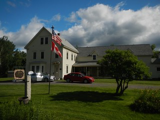
I exited the trail at the East B Hill Road and Hedy was waiting to pick me up. She had established new HQ at the Upton House Inn, about 5 miles from the AT. It turned out that the Upton House Inn was a wonderful oasis for us. It is run by Charlotte Dominique and Bob Pepler, two of the kindest folks you’ll ever find. We liked HQing there so much that even though I was hiking further north and the drive back was getting quite long, we still would want to opt for an additional day. It was sad when we had to leave the Upton House Inn for another HQ. Bob gave us a bottle of his special Merlot to take with us.
7-6-2014
East B Hill Road to South Arm Road
10.1 miles
This hike began with an immediate climb to Wyman Mountain followed by a steep drop into Sawyer Notch. Then another steep climb to Moody Mountain.
7-7-2014
South Arm Road to Maine 17
13.3miles
By this time I was all business. Get up, hike, do it again the next day. This section involved a stiff climb up Old Blue Mountain, then a ridge walk to Elephant Mountain and Bemis Mountain and its various peaks.
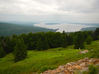
Maine 17 has a tourist pull out with a wonderful view of Mooselookmeguntic Lake.
7-8-2014
Zero Day
My little finger and ring finger on my left hand had swollen and my wedding ring was getting squeezed. Hedy and I decided to head into Rumford and have it looked at. We got an early start and walked out of the Rumford ER around 8:15 am. X-rays showed a broken pinkie but since healing had already been taking place they recommending a simple cast. We spent the rest of the day running errands and then headed to Portland to pick up my daughter Vivian and my grandson Andrew. They were going to spend a week with us on the AT adventure.
Their plane was a bit late and we didn’t get to pick them up until around 12:30 am, July 9. We arrived back to the Upton House Inn around 3:15 am. At 5:15 I was up, had breakfast and Hedy was running me out to the trailhead. I cannot take 2 zero days in a row.
7-9-2014
Maine 17 to Maine 4
13.1 miles
This is the first hike where there was not a significant gain in elevation. The morning part of the hike involves a climb up Spruce Mountain and then goes through an area of 4 ponds—Moxie, Long, Round and Sabbath Day Ponds. Unfortunately, near the end of the hike I once again became disoriented and began back tracking. By bad luck I did not have my GPS with me and when I realized my mistake I could not pinpoint where I was exactly. This probably cost me 2 hours as I was pretty certain I would exit the trail around 4:00. The hiking was not difficult, just a bit boggy. Once I oriented myself and located South Pond visually, I was good to go. I’m not sure where I went astray but like on the first day on Mount Washington I was very focused on getting it right. Hedy, Vivian, and Andrew were in the parking lot waiting for me when I arrived.
7-10 to 7-13-2014
Maine 4 to Maine 27
32.2 miles
The Official Appalachian Trail Guide to Maine calls this 32.4 mile section “the most difficult along the AT”. The gain in elevation is 11,200 feet (northbound). The major peaks crossed were Saddleback Mountain, The Horn, Saddleback Junior, South Crocker and North Crocker. The AT skirts 3 other major peaks—Mount Abraham, Spaulding Mountain, and Sugarloaf Mountain.
My plan was to break this section into 4 parts. The first part was a hike up Saddleback Mountain and The Horn. Here is a short video I took between these two peaks—
This left me with a steep descent to the Redington Stream Campsite. This campsite is featured prominently on the Maps but I could easily have passed by it. There was no permanent sign to mark the campsite, just some blue blazes. Fortunately somebody placed a laminated paper map of the area and hung it from a pine and that is what caught my eye. The Redington Stream Campsite is a large area that appears to be from the Blair Witch project. The entire area is strewn with broken branches and fallen trees. However, there is an excellent water source about 2 tenths of a mile in. This day’s hike covered 8.2 miles.
The following morning I set off for the Spaulding Mountain Lean-to hoping to find a tent site. I ascended Saddleback Junior, made steep descent to Orbeton Stream. That left me with the afternoon to summit Lone Mountain. This one was a challenge. It was a steep hike, late in the afternoon and I was running on fumes. In the late afternoon I set up camp near the Spaulding Mountain Lean-to. I was very fortunate this year—I never had to stay in a shelter as I always found a decent campsite. This day’s hike covered 10.5 miles.
The following morning I set off on the third day of this section. Sugarloaf Mountain was a bit of a challenge as the decent becomes very steep in parts, similar to earlier parts of the AT in Eastern Maine and the White Mountains of New Hampshire. I do alright on these steep parts as long as I stay focused and move methodically and slowly. The AT led to the South Branch of the Carrabassett River which involved a ford but was not too bad. A plank had been situated over the deepest part and the rest was rock hopping. I ended the hike at Crocker Cirque in the early afternoon. This section was 6.2 miles. This might not seem like much but I was really left with no alternative as I was not prepared to summit Crocker Mountain and then be left with a 5 mile descent to Maine 27. That would have to be left for the next day.
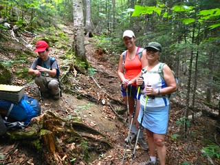
The final day of this section involved summiting the South and North Peaks of Crocker Mountain. At the summit of the North Peak I met up with Chicken Fat, a college student through hiking from Katahdin to Springer. He was with a group of 4. Two had fallen by the wayside and gone home. I can understand because one doesn’t really know what they are getting into when they start the AT. And they started in Maine which I think would be daunting. Anyway, Chicken Fat and I had a good conversation. I feel he will complete the hike—everything is in place, attitude, conditioning, persistence to achieve a goal. I left Chicken Fat and began the descent to Maine 27. About a mile before the highway I saw a little head bob into view. It was my grandson Andrew. My daughter Vivian and wife Hedy came bobbing into view shortly afterward. They had come to surprise me on the trail and they did. A section hiker, Lucky Pierre, had let them know I was about 30 minutes behind him. It was great to see my family after this arduous hike. Today’s final section was 7.3 miles.
7-14 to 7-15-2014
Maine 27 to East Flagstaff Road
16.7 miles
It’s funny how, even after all these years hiking on the AT, I can look at a map and think 16.7 miles-I should be able to do that. But then experience tells me no. This is Maine, the trail is extreme, there is no advantage to hiking your legs out. So, I planned to do this section in 2 days.
Hedy had moved our HQ to Stratton, Maine to a the Mountain View Motel about 5 miles from the junction of the AT with Maine 27. This proved to be a great place to HQ for the remainder of our time. We had a double room with a kitchen and small living area that worked well for the family. The area was right next to the section I would be hiking with a view of Cranberry Peak and Bigelow Mountain.

The morning of July 14 I set out on the AT from Maine 27. The day’s hike was going to be all uphill and my goal was the Avery Memorial Campsite that lies between the West Peak and Avery Peak of Bigelow Mountain. There were some extraordinary views on the hike, especially of The Horns Pond. I arrived in the mid-afternoon to the Avery Memorial Campsite. The day’s hike was 8.0 miles. Here is a video from the West Peak of Bigalow—
Video: West Peak, Bigelow Mountain
The next section involved descending Avery Peak to Safford Brook and then summiting Little Bigelow Mountain. The Little Bigelow summit area is about 2 miles and then the AT drops another 3 miles to East Flagstaff Road. I arrived mid-afternoon and the day’s hike was 8.7 miles.
7-16 to 7-17-2014
East Flagstaff Road to Caratunk
19.9 miles
This was my final section of my 11th year hiking the AT. I was feeling very good about the progress I had made and planned to finish at Caratunk, Maine, just 151.3 miles from Katahdin. Vivian hiked the first portion with me to Long Falls Dam Road. This was a bit of an adventure because we expected to see Hedy and Andrew at Long Falls Dam Road to pick Vivian up. We had scouted the pickup point earlier and it was with some trouble that we found it. Hedy got disoriented when she tried to locate the pick-up spot and we waited about an hour before she showed up. We were happy to see her because we couldn’t understand why she wasn’t there and then the bad ideas creep into your mind.

The road had some blue paint sprayed on it saying that this was the 2000 mile point on the AT. My Appalachian Thru-Hikers’ Companion had the 2000 mile mark just a bit north of Avery Peak, about 11.7 miles back. But the Companion is 2009 and the AT overall length isn’t a fixed number. When I checked today it was listed as roughly 2180 miles (Appalachian Trail Conservancy). But, I felt good to have reached this milestone.
I continued alone from Long Falls Dam Road through terrain that was basically ponds, swamps, and bogs. There was no climbing of note. I set up camp for my final night about 2 miles north of East Carry Pond near the Main Logging Road. The day’s hike was 11.7 miles. Here is a short video of East Carry Pond area—
The following morning I hiked into Caratunk, 8.2 miles. I arose earlier than usual and marched to the Kennebec River to catch the ferry to Caratunk. It was available from 8:00 to 11:00 and 2:00 to 4:00. I arrived about 10:30am and made the 5 minute walk to the AT parking lot where I will begin my final hike next year.
