Section 1, Appalachian Trail
from: Springer Mountain, 0.0 miles
to: Sam’s Gap, 315.2 miles
June 12, 2004 to July 12, 2004
Section 1 miles: 315.2
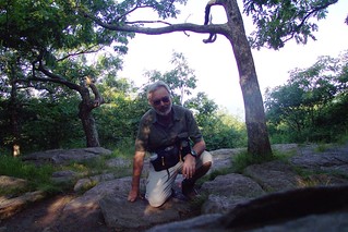
Just a bit of background—my name is John Hayes and I live in San Antonio. At the time of this hike I was 55 years old and had somehow wrangled 30 days to begin this great explore. I left my wife and 3 daughters in San Antonio. I did not have a trail name. In fact, I didn’t really know what they were. I was very green. My plan was to hike the AT by sections. Each year, during July, I have 11 vacation days. Add in the 4th of July holiday and weekends and I can spend two full weeks hiking and still make it back to work in time. I had no idea how many years that would take.
As I sit here and write this 5 years later and think back to that time and the subsequent hikes and experiences, I find it a bit overwhelming and humbling. I leave for the 6th leg of this journey in two days and I have not yet reached the half-way point. This thought is staggering. Each year I am a bit older and the trail remains a yearly challenge.
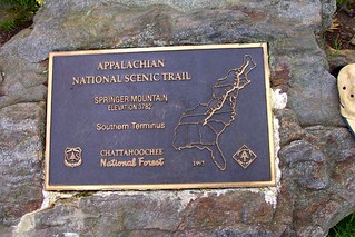
The hike begins at Springer Mountain, Georgia, June 12, 2004. I arrived in Atlanta, Georgia on the previous day and was picked up by Josh Saint at the end of the Atlanta Metro run. He shuttled me back to his and his wife’s (Leigh) Hiker Hostel in Dahlonega where I spent the night in anticipation of getting started in the early morning. Leigh shuttled me to the closest point on the AT and provided directions for where I needed to go to reach the Springer Mountain Trailhead. I had to backtrack about a mile to reach Springer Mountain, then retrace my steps as I began the longest journey of my life.
Like most inexperienced hikers I made a lot of mistakes and these became evident almost immediately. I was over packed, close to 45 pounds. I trudged my way to somewhere shortly past Hightower Gap (8.1 miles) where I set up an elaborate campsite. I had a two man tent (7 pounds), drop cloth, clothes line but no real food to eat. For some reason I thought I could survive on crackers and peanut butter but I realized that one quickly tires of that kind of fare and in fact, it becomes repulsive to eat. But, for the first few days of hiking I thought I could get away with it until my body began to tell me different.

At the trailhead I ran into a couple of hikers who had 60 days planned. Unfortunately, I only got one of their names on the back of a business card-J. Willett of Millersville, PA. I wonder what happened to them? They had a plan of doing 20 miles a day and reaching Harper’s Ferry. It sounded reasonable when they laid it out for me but in the subsequent few days it became evident that that wasn’t going to happen. We crossed paths for the first several days. I last saw them near Hiawassee, about 67 miles into the journey. I have a photo of the three of us, just before they set off to Fontana Dam, the first major milestone on the trail. One was a PE teacher and the other was a minister.
At the 82 mile marker I crossed my first border and entered North Carolina. At 134 I hit the Nantahala River and stayed at the hostel there. This was a great place to get something to eat and get cleaned up. The following day proved a brutal one for me. I hiked to the Brown Fork Gap Shelter but when I was coming down Stechoah Gap I slipped on some green moss and my leg was caught between two rocks. After the initial fall I thought I might have broken it but I didn’t. I arrived at Brown Fork Gap shelter with the leg stiffening. I was barely able to hike the 1/4 mile for water so I could cook dinner (I purchased a Pocket Rocket in Franklin). The next day I only made 6 miles and limped the whole way. But the following day I hiked into Fontana Dam and by the time I had reached it there was little or no pain or stiffness. I guess I just walked it off.
Fontana marked the beginning of the Smoky Mountains. The Smokies were covered in clouds for the week it took me to hike through them.
The high point of the hike was the hike into Hot Springs. By this time I was doing fairly well (hiking legs-wise) and the approach to this beautiful community was memorable.
I do have some records of the hike and even though I am writing this 5 years after the fact I can supply the following information—
June 12, 2004
Near Hightower Gap (Carrying a heavy pack. I even have clothes for the plane ride home and 3 changes of underware and an extra pair of shoes. It is remarkable how quickly one realizes the absurdity of toting all that stuff.)
8.1 miles from Springer.
June 13
Hightower Gap to Gooch Mountain Shelter
6.5 miles (Pretty pathetic second day. Stayed in my tent until 10:30 or so because I thought it was raining. Turns out it was simply the wind blowing the trees). You know, 6.5 miles doesn’t sound like much, and it isn’t. But those were very rough miles, especially for a novice with a 45 lb pack.
14.6 miles from Springer.
June 14
Gooch Mountain Shelter to Woody Gap
5.4 miles
Another pathetic outing. Sometime, in the early afternoon I staggered into Woody Gap and Ga 60 where it was rumored that ice cream was available just 2 miles to the west. I had no idea that 2 miles was so far. In the process of trying to reach the gas station/grocery I ran into some folks who recommended I stay at the Goose Creek Cabins and slack pack for a while. This sounded like a good idea because what I was doing wasn’t working. By the way, for 3 days I have been hiking in Cottons which I was warned not to bring. They never dry out. Never. The whole time I hiked it was like a sauna.
20.0 miles from Springer
June 15
Woody Gap to Neels Gap
10.7 miles
Arrive at Neels Gap about 5:00 PM and am then shuttled to Goose Creek cabins. I slacked pack for 3 days using Goose Creek as my HQ. Still trying to figure out how this whole thing works. In the meantime, my two unnamed friends have had similar issues as we continually cross paths and swap mishaps. There packs are even larger than mine. However, slack packing certainly increases the mileage achieved and the enjoyment of the experience.
30.7 miles from Springer
June 16
Hogpen Gap to Neels Gap
6.4 miles
This is the only time that I have hiked on the trail from North to South (I am writing this after having completed up to Boiling Springs, PA). I was getting the idea that unless it was absolutely convenient that slack packing wasn’t the way to go. It was odd hiking backwards and I didn’t want to repeat that. I was also trying out some new hiking sandels. I continued to use these for various future AT hikes and probably have about 300 miles on them. Not bad for blistered feet. At Neels Gap I re-equiped myself, got rid of a lot of excess stuff (not everything) and so was better prepared. I was still eating cold but I had improved my footware and hiking clothes. No more cottons.
37.1 miles from Springer
June 17
Hogpen Gap to Unicoi Gap
13.6 miles
Back to full pack hiking. This time my pack is lighter and my footware better. At Unicoi Gap I hitched into Helen and stayed at a Motel 8 (I think).
50.7 miles from Springer
June 18
Unicoi Gap to Sassafras Gap
10.0 miles
Tented at a campsite here. Crossing the trail with EagleScout and an AT RidgeRunner, a young guy hoping to hike in Peru.
60.7 miles from Springer
June 19
Sassafras Gap to Dicks Creek Gap
6.1 miles
Ran into my two unnamed trail buddies for the last time at US 76. This was the early afternoon. They were moving forward to Fontana Dam and I was going into Hiawassee for a room and food. My early days, I can now see, were centered on getting to comfort areas. This resulted in some pathetically short days.
66.8 miles from Springer
June 20
Dicks Creek Gap to Deep Gap
15.6 miles
I ran into Eagle Scout who was slack packing in the reverse direction. This was at 6 miles into the hike for me. He condescendingly shared with me that he was going to be completing 15 miles today, much too far for me. Ha, I did 15.6 and set up a tent. I remember the clarity of the warm night as I left the rain cover off and how good it felt to prove Eagle Scout wrong. Note-crossed into North Carolina around 3:00 PM. That was a nice milestone.
82.4 miles from Springer
June 21
Deep Gap to Big Spring Shelter
15.3 miles
Climbed over Standing Indian Mountain, the highest AT mountain south of the Smokies. And, another big day, mile-wise.
97.7 miles from Springer.
June 22
Big Spring Shelter to Winding Stair Gap
10.0 miles
At Winding Stair Gap is US 64 where I hitched into Franklin. I stayed at the Micro Hotel which had a great hiker rate, I believe $25 for a very nice room. At Franklin is an excellent outfitters where I was able to readjust my equipment once more. This time I mailed a bunch of stuff back home (shoes, tarp, water bottles and other stuff) and purchased a pocket rocket-a compact camp stove. I was going to start eating better. And another milestone was reached-my first 100 miles.
106.8 miles from Springer.
June 23
Winding Stair Gap to a campsite near Wayah Bald
10.5 miles
If I recall, I had now adjusted my thinking to go more than 10 miles a day, minimum. The only exception would be for hitting a trail town where I would position myself close and arrive early to maximize the time in town.
117.3 miles from Springer.
June 24
Near Wayah Bald to Wesser Bald Shelter
11.1 miles
128.4 miles from Springer.
June 25
Wesser Bald Shelter to Nantahala River
5.7 miles
I arrived at the Nantahala River around noon and checked into the local hostel, washed my clothes, ate great food, met other hikers and a church group that fed all of us.
134.1 miles from Springer.
June 26
Nantahala River to Brown Fork Gap Shelter.
16 miles
By far the longest day of hiking in my life. I started at 6:45 am and finished at 9:00. Around 7:00 I was approaching Stecoah Gap (NC 143) when I wedged my leg between two boulders on the trail. At first I thought I might have broken it or at least sprained it but I was able to walk it off. However, by the time I reached the Brown Fork Gap Shelter I was utterly exhausted and my leg was stiffening. I was barely able to get to water (I was going to heat up a can of pea soup with my new Pocket Rocket).
150.1 miles from Springer
June 27
Brown Fork Gap Shelter to Cable Gap Shelter
6.1 miles
Not really a pathetic day because I literally limped the 6.1 miles to the shelter. I ran into two brothers, Mop Handle (6th grader) and FountainBleu (Grad student). They were from Georgia, Neels Gap area actually and were hiking back from the Smokies with their trail dog. We had a good chat and then they pressed on to the next shelter. My leg was stiff but felt better.
156.2 miles from Springer
June 28
Cable Gap Shelter to Fontana Dam
5.5 miles
Great stop for a room and food. Crossed paths with Crazy George who I would hike with for a couple of days. He was a retired school counselor from New Hampshire doing the AT for his 3rd time. He had it down to a science. Crazy George helped me settle on a trail name—Gravelboy. The name comes from a 1999 motorcycle trip I took to Alaska. There were many gravel roads which weren’t very nice for a motorcycle and that’s where I got the name Gravelboy. Perfect trail name.
Fontana Dam is another trail milestone as it is listed in the data book as the terminus for the North Carolina-Georgia section. Now I would be hiking in the second section of the AT, the Tennessee-North Carolina section.
161.7 miles from Springer.
June 29
Fontana Dam to Mollies Ridge Shelter
12.4 miles
First day in the Smokies.
175.0 miles from Springer.
June 30
Mollies Ridge Shelter to Derrick Knob Shelter
11.7 miles
Hiking in the clouds. Can’t really see much. Shared the shelter (you can only stay in shelters while in the Smokies) with an older couple and a lady hiker from Texas, the three of them heading in the opposite direction.
186.7 miles from Springer.
July 1
Derrick Knob Shelter to Mt. Collins Shelter
13.5 miles
Visited Clingmans Dome (in the clouds) for the first time. This is the highest point on the AT.
200.2 miles from Springer.
July 2
Mt. Collins Shelter to Newfound Gap
4.5 miles
At Newfound Gap is an embossed map of the AT where FDR gave his speech to open the Smokies as a National Park. I was humbled by this map as I could see I had barely hiked but a tiny bit of the AT. I hitched into Gatlinburg where I spent the night, readjusted my equipment once again, purchased new hiking boots and had a great steak dinner.
204.7 miles from Springer
July 3
Newfound Gap to Pecks Corner Shelter
10.4 miles
Shared the shelter with some locals who were quite the riot. They were out for a week to hike the Smokies and had huge packs filled with beans. Of course, this provided for the night music.
215.1 miles from Springer.
July 4
Pecks Corner Shelter to Cosby Knob Shelter
12.9 miles
Just outside of Pecks Corner Shelter I hit some slippery rocks and spilled off the trail and flopped down the mountainside a bit. This is a bit weird because of the full pack and it’s spinning around, the hiking poles are strewn about and I lost my Grand Canyon cap. It took about an hour to recover everything and get back on the trail. This spill was similar to the earlier Stecoah Gap spill in that both involved large flat boulder surfaces covered in green moss.
228.0 miles from Springer.
July 5
Cosby Knob Shelter to Davenport Gap
8.0 miles
This is the terminus for the Smokies and I was expecting another Fontana Dam experience. To my disappointment there really isn’t much at Davenport Gap. I did find a hostel with a grill and that worked out OK. I also hooked up with a young HS grad who was hiking the entire trail before heading off to college at Northern Arizona University in Flagstaff. What a great thing to do before starting college. His name was Mike. I don’t remember his trail name unfortunately.
236.0 miles from Springer.
July 6
Davenport Gap to Deep Gap
9.6 miles
Got a late start (10:00 am). I don’t remember why.
245.6 miles from Springer.
July 7

Deep Gap to Roaring Fork Shelter
11.3 miles
This hike I crossed Max Patch. This is a wonderful open area with beautiful views. I would hit more similar sites in the next few days (balds).
253.8 miles from Springer.
July 8
Roaring Fork Shelter to Hot Springs
14.9 miles
Surprisingly, I reached Hot Springs in the early afternoon. This is a long hike but I made great time and arrived around 3:15 PM. I checked into a wonderful downtown motel, readjusted my equipment once again at the local outfitters in anticipation for next years section. I purchased an MSR hubba and cut a deal for a shuttle to Knoxville from Sams Gap. The day was perfect.
271.8 miles from Springer.
July 9
Hot Springs to Spring Mountain Shelter
11.0 miles
282.8 miles from Springer
July 10
Spring Mountain Shelter to Jerry Cabin Shelter
15.3 miles
I probably hiked around 20 miles because after taking a break I became disoriented and hiked the wrong way for 40 minutes or so before I came to a landmark that I recognized. This might seem impossible but for the most part the hiking is through a green tunnel. So, the landmark I came to was a spot on the trail where you had to step up (or down). I remembered a wedge in the rock where I could put my foot and a tall skinny tree that I could hold onto for support. That was when I realized I had been hiking in the wrong direction. This part of the trail is the one section in the entire 2000+ miles where the trail bends around and heads south. So, because I wasn’t certain where I was I couldn’t use my compass. Fortunately I hiked to a trail marker and was able to orient myself. I arrived at the Jerry Cabin Shelter about 8:00 PM, exhausted of course. And the water source was a quarter mile away and a poor one. I had to scoop water from a mud puddle.
298.2 miles from Springer.
July 11
Jerry Cabin Shelter to Hogback Ridge Shelter
14.6 miles
This was my final night for this first section hike. I reached the Hogback Ridge shelter about 5:25 PM and cooked dinner, set up my new Hubba. This is where I met the hiker Sebastian who had started out from Springer 16 days prior. I was amazed by this guy. He had done the AT already, the Continental Divide Trail and the Pacific Crest Trail. For him, it was nothing to do 28 miles in a day. In fact, that was about his norm. He shared with me his philosophy of the trail. Go as light as you can. That way you consume less water because you aren’t working as hard and you can move faster. He had a single 20 oz plastic soda bottle that he used for water. He would eat cold. Wow. This guy really knew his stuff. I did not realize that while this worked great for him it might not be a good idea for me. But the damage had been done. My second section hike would be a disaster because I implemented Sebastian’s ideas. See At 2005.
312.9 miles from Springer.
July 12
Hogback Ridge Shelter to Sams Gap
2.5 miles
I arrived at Sams Gap about 9:00 AM. Said adios to Sebastian as he was heading on to Erwin. My shuttle driver arrived within the hour and I returned to Knoxville.
