Section 9, Appalachian Trail
from: Salisbury, Connecticut, 689.7 miles to Katahdin
to: Stony Brook Road (about 0.6 miles North of Stony Brook Shelter), 477.3 miles to Katahdin.
July 1, 2012 to July 17, 2012
Section 9 miles: 212.4

The 9th section hike is complete. My final day on the Appalachian Trail was July 16. I hiked from Vermont 4 to where the AT crosses Stony Brook Road. This is marked on the Appalachian Trail Official Map as a Parking Area, however it is not referenced in the Thru-Hiker’s Companion guide. The Stony Brook shelter is located 0.6 miles South of this parking area 477.9 miles to Katahdin in Maine. So, using my best arithmetic our stop at the junction of the AT with the Stony Brook Road parking area is 477.3 miles to Katahdin.
Hedy shuttled me once again this year and that is why I was able to hike so many miles. I have 3 daughters: Vivian, Nataly, and Sophia. Nataly joined me for the first week and hiked 40 miles of the AT. It was fun to have her hike with me and I got some great photos of her on the trail. Hedy also took some great photos.
We began at the parking lot near Salisbury where we left off the year before where I completed section 8. There is a parking area at Conn 41 (reference Massachusetts-Connecticut Map 3, Appalachian Trail Official Map). This is listed at 689 miles from Katahdin. So, for this 9th section I completed 212.4 miles. This was the most miles I have completed for a section (not counting the first section because I was out 30 days). Here are the details and a few comments—
July 1, 2012
US 44 at Salisbury, Conn. to Race Brooks Fall Trail Campground
11.6 miles
The first day turned out to be the most eventful of this 9th section hike. It was Nata’s first time on the AT and, in fact, her first time to carry a full pack. We had our sleeping bag, tent, and gear for this section, planning to have Hedy pick us up at US 7 or Mass 23 on the AT. We didn’t make it that far.
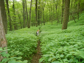
Unfortunately, for Nataly, this turned out to be a rough section of the AT and it was very hot. We found the going to be tedious—starting at Conn 41 we had a climb to the Lion Head, followed by another ascent to Bear Mountain where we had a steep descent and then another climb up Race Mountain. During this time we got off the trail twice, both times I would attribute to “zoning out”. “Zoning out” happens when your mind diss-atunes itself from hiking. We found ourselves on an excellent trail and just followed it without looking for blazes. Nataly mentioned to me that she hadn’t seen a blaze for some time and that woke me up. We walked a bit further where the trail terminated at a service road with no sign for the AT. It was quite evident that we were off the trail. We had to backtrack about 1/2 mile and we found a blaze marking a scraggly trail angling off our nice trail. This was unfortunate but it almost always happens at least once on a section hike. It is very tiring because we were carrying packs, we weren’t sure how far we would have to backtrack, and we were losing valuable time. A bit later in the day we got off the trail once again but this time we didn’t go very far before we backtracked and realigned ourselves. We rolled into the Racebrook Falls Trail at dusk and set up our tents.
Our Blair Witch Experience
At about 2:00 in the morning we heard an ungodly, not-from-this-earth moaning-wailing sound. It had the hopeless moan of something living watching its life sucked out from them. To call it spine-chilling would be an understatement. I would call it Blair-witchish. A few seconds later the moan was repeated. Each moan lasted for 3 or 4 seconds. I have no idea what it was. In the morning we asked a fellow hiker if he had heard the sound but he hadn’t. He uses a hearing aid and, of course, had it turned off for the night. In talking with other hikers in the following days we never did get a fix on what could make such an ungodly sound. It happened at the Racebrook Falls Trail campground, July 1, 2012, at about 2:00 am.
Note—Several years after this hike I began to think back on this ungodly event and started to do some research. I am quite sure, after my research, that what we heard was a loon. The All About Birds site had some examples of loon calls. There are quite a variety of sounds they make but the loud, clear, haunting sound of hopelessness is what I remember from this experience.
Audio: Dad’s reflections
[Dad] It’s July 2nd, early in the morning. Nata there is just breaking camp. We’re preparing to climb Mount Everett. Yesterday was very exhausting. We only made 11.6 miles. Um. We got off the trail one time and probably lost an hour on doing that. We missed a blaze. Um. During the night there was a very strange, incredibly loud noise. I thought it was a woman shreiking. Nataly thought it was a bear. Um. Then after a minute or so it was repeated. And it was… it was freaky. Um, we’re going to try to find out what that was today. I’m kind of thinking it was an owl, perhaps, or something like that. But, uh, we have no idea. It’s just very strange. I’ve never heard anything like that before.
Audio: Nataly’s reflections
[Dad] Here’s Nata…
[Nata] I can fully appreciate the comforts of home at this time.
[Dad] Anything else?
[Nata] Um. I guess loud sounds make me think it was a bear and that we were about to be attacked. But we’ll find out, hopefully, what it was. It was extremely loud, whatever it was shrieked twice, long and low, and after that I heard owls and every single noise in the forest. I probably stayed up a couple of hours after that.
[Dad] It was very Blair witchy.
[Nata] Yeesss.
July 2, 2012
To Mass 41
6.2 miles
Extremely hot and difficult day even though we only did 6.2 miles. Coming over and off the Jug End was challenging.
July 3, 2012
To Mass 23
12 miles
July 4, 2012
To Tyringham, Mass. Main Road
12.1 miles
July 5, 2012
To Washington Mountain Road
18 miles
July 6, 2012
To Cheshire, Mass.
18.3 miles
The first part of this hike Nataly hiked with me into Dalton. It’s always fun to walk into and through a trail town.

July 7, 2012
North Adams, Mass.
14.6 miles
July 8, 2012
To Vermont 9
18.4 miles
July 9, 2012
To a bit north of Kid Gore Shelter
14.4 miles
For the next 3 days I would be back to carrying a pack again. The alternative would have been to have Hedy pick me up at a parking area that was 22.6 miles from Vermont 9. The parking area was accessible by a dirt road (Stratton-Arlington Road). That would leave a 17.5 mile hike the next day to Vt 11 & 30. This was just not realistic and I had to break the hike into three days and camp out.
I reached the Kid Gore Shelter (actually a bit north of it). That was a tough 14.4 mile stretch. If I had attempted to get to the parking area that would still be another 8 miles or so and I would have arrived very late, probably 9:00 in the evening. I am happy that I did not make that aggressive choice.
July 10, 2012
To Stratton Pond Shelter
15 miles
July 11, 2012
To Vt 11 & 30
10.7 miles
The Chipmunk Story.
At Prospect Rock I took a short break to locate the trail. There was no clear indicator for the AT but there was a generic trail sign. I just wanted to make sure it was the right trail. I set my pack down and scouted the area, determined that the AT was indeed the identified trail and then took a short walk down to the Prospect Rock viewpoint. When I returned I leaned against my pack to rest a bit before taking off. I heard a rustling sound and got up to see if I could find what was making it. Nothing. I heard it again a few minutes later and thought it might be a bear or a deer. But when looking around the area-nothing. I packed up and headed down the AT about 2 miles to the Spruce Peak shelter and ran into a hiker called Stats. I set down my pack while we chatted. To our surprise a chipmunk worked its way out of my pack and scurried off. Mystery noise solved. A chipmunk had stowed away in my pack and I had carried it 2 miles down the trail. I wished him well and was sorry that I moved him from his home.
July 12, 2012
To USFS 10, Black Branch
17.8 miles
July 13, 2012
To Vt. 103
14.6 miles
July 14, 2012
To US 4
17.4 miles
This might have been my most challenging and exhausting day on the AT. I was hiking at 6 am and finished at 7 pm. The hike involved going through an area of the AT that was devastated by a hurricane last year. The trail was actually marked rerouted but the word on the trail was just follow the blazes.
The hike began with a steep climb from Vt 103 to Clarendon Lookout. This was followed by about a 6 mile hike to the base of Killington Mountain and then an ascent of about 2000 feet over 4 miles. This is not a steep climb, just a nice steady gradient. However, with the heat and the long approach it was draining. From Killington peak area it was basically downhill to US 4.
The hike was so exhausting that I chose to take a zero day and make my final hike on the 16th.
July 16, 2012
To Stony Brook Shelter
10 miles
My final hike took me to Stony Brook Road where there is a parking area. Well, that’s the way it is marked on the official AT Map 6 for New Hampshire-Vermont. In reality Stony Brook is a narrow dirt road. It gets increasingly more deteriorated as you approach the junction with the AT. Near where it crosses the AT there is a slight widening of the road and that is the “parking area”. This is a difficult place to get to but we had scouted it out the day before and so Hedy knew exactly where to pick me up.
The advantage of doing this 10 mile hike was it positions us for next year. The next hike will be about 13 miles and that is very doable.
And so, this is where I will begin my 10th section hike-Stony Brook Road, July 2013, God willing.
Some of the people we met on the trail—Baked Beans, Robert E Lee, Bobcat, Daddio, Trog, Sliderule, Slider, Honest Abe, Chicken Little, Old Goose, Chicken Feathers, Princess Doah, Alpo, Stats and many others.
