Posted on

Grand Canyon 2022

Hedy and I arrived to Roswell, New Mexico, Oct 6 and the next day in the late afternoon to Tusayan, Oct 7. The drive is more than 1000 miles from San Antonio and it is a killer. Also, on Oct 6, my youngest daughter Sophia and her husband Tommy flew into Phoenix on Oct 6 and drove a rental car into Tuscayan Oct 7 and were able to get a helicopter tour of the Grand Canyon.

Grand Canyon 2022
Tommy and Sophi at the Grand Canyon West Airport.

This was the first time for Tommy at the Grand Canyon and together they got some spectacular photos from their trip.

Grand Canyon 2022
Spectacular view from the helicopter of Marble Canyon, AZ.

In the meantime Hedy and I were 400 miles away working our way to Tusayan. Lesson learned—don’t  drive to the Grand Canyon from San Antonio. We lost 2 days at the canyon by being on the road.

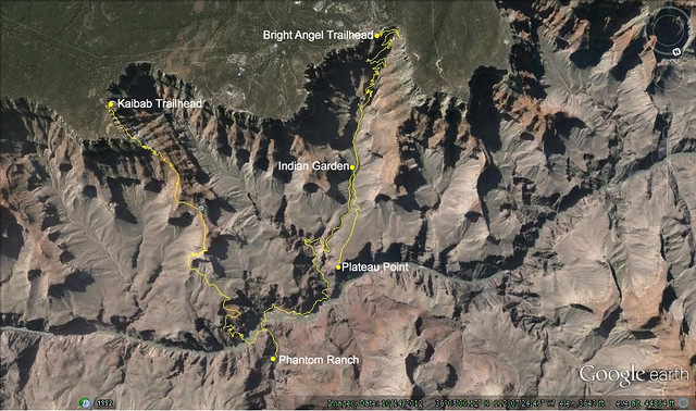
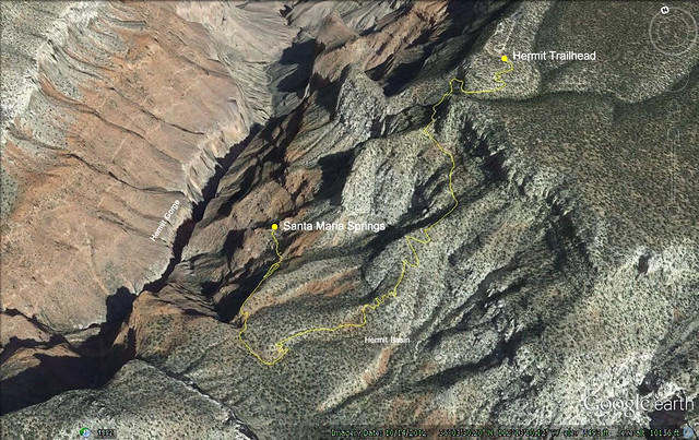
On Saturday, Oct 8, Hedy and I joined with Tommy and Sophia to hike together to a spot near Comanche Point where we scattered the ashes of my beloved dog Colter. Sunday and Monday Hedy and I explored the Rim from the South Kaibab area to Hermit’s Rest. Tommy and Sophi miraculously got standby reservation for Phantom Ranch and hiked down on Sunday and returned Monday where we met them at the trailhead.

We celebrated Tommy’s initial hike into the canyon and welcomed him as a member of the club (those that have hiked to the Colorado and returned alive). We had dinner at the Plaza Bonita in Tusayan and the next day we were back on the road for San Antonio.

The main purpose of the Grand Canyon visit was to scatter the ashes of my beloved dog Colter. He had been to the Grand Canyon with Hedy and me in 2016 and again in 2017.

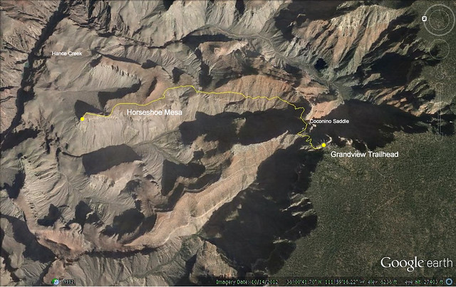
In 2016 he was mostly with Hedy while I was doing a hike form Grandview Point to the South Kaibab. Hedy and Colter left me at Grandview Point and picked me up at the South Kaibab parking area, 4 days later. They spent a lot of time rim walking and taking photos of the spectacular views and abundant wildlife.

In 2017 Colter and I did a trail hike to Cape Solitude that follows a two track jeep trail that has not been used for many years. We had a great time. Probably my favorite Grand Canyon hike. I had always wanted to hike with Colter in the Grand Canyon and this was the perfect hike—isolated and the trailhead was 2.7 miles from the East Entrance parking area. That was the prelude to the actual unnamed trail we were to follow. So, it wasn’t an easy hike but since it did not require going below the rim, dogs are allowed. Perfect situation for Colter and myself. Colter had been with me for 16 years and we walked/hiked hundreds of miles together. Such a great friend and companion. I miss him dearly.

See Grand Canyon 2022 for description of the 4 days.

Posted on

April 2017 Cape Solitude

Government Canyon
My best friend Colter.

April 18 and 19 (2017) I completed a Grand Canyon hike to Cape Solitude, a unique viewpoint of the confluence of the Colorado and Little Colorado Rivers.

Selected photos

I hiked this trail with my Australian Cattle Dog, Colter. I have always wanted to hike in the Grand Canyon with Colter but dogs are not allowed below the rim.  This was a mesa hike and we were unlikely to encounter other hikers. It was a perfect way to hike with my dog in the Grand Canyon.

On paper the hike doesn’t look bad. The problem though is water. There is absolutely no water to be found on the 15 miles to Cape Solitude.

None.

So, right from the start we were managing water.

Here is a Google image with our GPS tracks of the hike.

CapeSolitude4

When I first saw this hike it intrigued me. It looked like it might be completed in a single day. But, as I researched it I had to reconsider that idea. My goal was to hike with my dog, explore the mesa a bit, and get some photos of the confluence in the evening and morning hours. And I also knew from previous hikes that I seem to overestimate my hiking prowess. A voice in my head told me to tone it down. So that’s how Colter and I approached this hike—a two day photographic adventure.

For details of the hike please see the Cape Solitude page.

Posted on

Grandview Point to South Kaibob Trailhead

I completed this major hike April 21, 2016 as planned. I have a detailed trip report posted.

Also, selected photos.

Grandview Point to South Kaibob Trailhead
GPS tracking for Grand Canyon hike-Grandview Point to South Kaibob Trailhead, April 2016

This was an important hike to me as it filled in a 20 mile section of the Tonto Trail that I had never hiked before. Hedy and Colter accompanied me to Tusayan and shuttled me to and from the canyon. The hike was 4 days and I exited the South Kaibob at about 5:00 pm. My rate for climbing out of the canyon was about 1/2 mile an hour due to the heat. I made frequent stops where I could find shade. Water was a problem but fortunately I was able to get a liter from a young man who was day hiking to Skeleton Point and nearer the top a couple gave me a 16 oz bottle and another couple filled a liter bottle for me from their hydration pack. I am thankful to these folks.

Now that I have completed all trails on the South Rim, what do I do? My daughter Nataly is planning a rim to rim hike that I would like to join. I also would like to hike with Colter to Cape Solitude. So I will be looking for opportunities to revisit the Grand Canyon.

Posted on

The 4th hike

I made a post on April 27, 2014 about the next 4 major hikes I would be taking. The four hikes would take me to two major milestones in my life−the completion of the Appalachian Trail and the completion of all trails on the South Rim of the Grand Canyon, most of them multiple times. The 4th hike will fill about a 20 mile gap of the Tanto Trail that I have not yet hiked. Last week I received the official permits so I can go ahead with my plans. For right now this is what I have in mind−

  • April 18, 2016 (Monday). Begin at the Grandview trailhead and hike down to Horseshoe Mesa and take the fork in the trail to Cottonwood Creek. I have hiked to Horseshoe Mesa on eight occasions throughout the years and am quite familiar with the Grandview Trail. As soon as I step on the trail to Cottonwood Creek I will be exploring new trail across the Tonto plateau to the South Kaibab. Cottonwood Creek is about 4.5 miles from the trailhead so this day’s hike is a short one.
  • April 19 I will hike to Grapevine Creek. This is 5.5 miles. Most of the hike will be contour hiking around the Grapevine Creek Canyon. This is the longest contour hike detour in the Grand Canyon.
  • April 20 I will hike to the Lonetree Canyon in a redwall amphitheater at 3640 feet. The area is marked by a few Cottonwoods and hopefully this will serve as a water source. The day’s hike is 8.7 miles.
  • April 21 I hike out. It is about 5.5 miles to the junction with the South Kaibob Trail and then a steep 4.5 mile climb out of the canyon.

And that’s the plan.  Hedy will most likely join me as we plan to drive to the Grand Canyon from San Antonio. We also plan to bring Colter, my Australian Cattle dog. Hedy and Colter will spend time topside while I am in the canyon and will meet me at the South Kaibob trailhead on the 21st. Of course, this is still quite a ways off but it is in the works. I look forward to exploring the Grand Canyon in April.

Posted on

Biggest hike…ever

June 27 Hedy and I leave for Portland, Maine, and should arrive there before noon. Our daughter Vivian will be accompanying us on the flight and the plans are, for now, that she will be hiking this final stretch of the AT with me. That’s a bonus for me. Vivian hiked the Escalante Route with me in the Grand Canyon this past March and is a solid companion for this sort of thing. In the early morning, Sunday, June 28th we will leave the Caratunk trailhead and head for Monson.

This final section hike will take 3 parts. The first part is Caratunk to Monson = 36.7 miles. We will have two nights out and Hedy will pick us up at Maine 15.

The second section will be Monson to Abol Bridge = 99.4 miles. This is called the 100 mile wilderness. We will be out for 7 nights and Hedy will pick us up at Abol Bridge and take us into Millinocket for the night.

The final section will be Abol Bridge to Katahdin (Baxter Peak) = 14.5 miles. We will be out for one final night and make the assent in the early morning from the Birches facilities. We’ll return that afternoon and Hedy will take us back to Millinocket. It is possible that Hedy might join us for the final assent which would be pretty cool.

Of course, this is all conjecture. We don’t really know what is going to happen. I have a few days “wiggle room” built in and Hedy and I plan to stop by Lincoln, Nebraska to celebrate with my mother and sister.

I call this the Biggest Hike Ever because it has been very challenging to prepare myself for each section hike the last 11 years. It has been wonderful to have the challenge though, as each summer I have had to prove to myself that I can do this. Eleven years in a row. Imagine that. Now is my chance to finish…hence my biggest hike ever.

Posted on

Escalante Route Complete

Vivian and I successfully completed the Escalante Route. As planned we began hiking down the Tanner Trail around 10:00 am on March 8, 2015 and completed the route March 12 about 5:30 p m. Here is a schema of our route—

Escalante Route, Grand Canyon
March 8 to March 12, 2015. Escalante Route: Tanner Trail – New Hance Trail. Red dots represent campsites.

I am currently creating the page for the trip report. In the report I will describe some of the problems we encountered with staying on the route (if you notice in the above schema that we backtracked near Seventyfive Mile Creek canyon, probably a mile or so due to bad information in the National Park Service informational sheet re the Escalante Route. This caused us to be a bit behind schedule on leaving the canyon as we had hoped to be out by midday.

Posted on

Escalante Route

Two years ago I intended to do the Escalante Route with Vivian but could not get permits. Imagine my relief when I received permits for this year’s spring break trip. I got my first choice and that enabled me to proceed with concrete planning for the trip. Here is a summary—

Sunday, March 8, 2015, Vivian and I will hike about 1/2 way down the Tanner Trail and set up camp. When I did the Tanner Trail with Sophia in March, 2012, we hiked to Tanner Beach the first day. That was a bit rough on my knees as the Tanner Trail has two very steep sections. By camping about 1/2 way down we will have completed 1 of the steep sections and leave the second for the next day.

Monday, March 9, 2015. The plan is to get to a campsite along the Colorado, somewhere between Tanner Beach and Hance Rapids.

Tuesday, March 10, 2015. The plan is to get near Hance Rapids

Wednesday, March 11, 2015. Hike about 1/2 way out of the canyon on the New Hance trail. We hope to camp near water that we happened across when Vivian and I hiked down the New Hance during March, 2011.

Thursday, March 12 we will hike out and should reach the rim before noon.

We’ll be HQ’ing at the Red Feather Lodge in Tusayan on March 7 and March 12 and return to San Antonio on the 13th.

Here is a link to some information about the Escalante Route http://en.wikipedia.org/wiki/Escalante_Route

Posted on

Four more hikes

I realized, in anticipation of the upcoming hike on the AT, that I have a few key hikes left to complete two major hiking milestones in my life. One major milestone  is the completion of the Appalachian Trail and another that I have not been consciously working toward, would be the completion of all hikes on the south rim of the Grand Canyon. Here’s how I hope it plays out—

Hike 1: June-July, 2014, 11th section of the AT. I am currently at the summit of Mount Washington and should set off June 26, 2014. I will hike as far into Maine as I can manage, understanding that the situation is much more difficult than in previous sections. The hiking last year was hard fought and I expect more of the same the final two years.

Hike 2: March 2015. I plan to do the Escalante Route with Vivian. I had hoped to do this in 2012 but was not able to get the permits. This will be a challenging hike and I’ve asked Vivian to join me for this as it involves some route finding and common sense. This is not a hike I would want to do alone.

Hike 3: July, 2015. This should be the final section of the AT to Katahdyn. I’m hoping the milage will be low based on the 11th section endeavor. Certainly this could be an emotional moment in my life.

Hike 4: March 2016. The final gap for the south rim trails is the Tonto Trail from Horseshoe Mesa to the South Kaibab. This is a contour run along the Tanto plateau with a stiff hike out the South Kaibab. The completion of this hike will fill all blanks on my South Rim map. And, most of the trails I have hiked multiple times, i.e. The Royal Arch Loop 3 times, Bright Angel and South Kaibab 5 times, Hermit Trail 3 times, Grandview Trail 6 times, South Bass Trail 2 times.

Right now my mental and physical preparation is for the Whites and Maine. I am really looking forward to this one. Hedy and I plan to fly into Portland, Maine, rent a car, and headquarter somewhere near the border where the AT crosses, probably on the Maine side.

I continue to hike in Government canyon on weekends.


Posted on

Grand Canyon with Josh and Nat

This spring break I hiked in the Grand Canyon with daughter Nataly and her husband Josh. We arrived in Tuscayan late in the evening of Saturday, March 8, 2014. The next morning we were hiking into Phantom Ranch by way of the Bright Angel Trail.

Grand Canyon 2014 Phantom Ranch
Josh and Nata ready to explore the Grand Canyon. We started out with a hike to Phantom Ranch and throughout the week (March 9 to 13, 2014) made day hikes to Santa Maria Springs, Horseshoe Mesa, and Plateau Point.

Here are the GPS track images of our hikes—

Grand Canyon 2014 Phantom Ranch
Bright Angel Trail to Indian Garden and Phantom Ranch. Return by Kaibab Trail.
Grand Canyon 2014 Santa Maria Spring
Day hike to Santa Maria Springs.
Grand Canyon 2014 Horseshoe Mesa
GPS tracks of Grandview Trail to left arm of Horseshoe Mesa. Day hike, March 12, 2014.

See all the details at https://gravelboy.edublogs.org/grand-canyon/part-15-march-2014-with-josh-and-nata/


Posted on

iMovie and iDVD

I struggled with iMovie to make this video. iMovie is what I have on my new MacBook Pro and I thought I should try it out, I really don’t want to purchase Adobe Premiere if I don’t have to. My experience is with Roxio VideoWave and Adobe Premiere. iMovie is a completely different experience. It seems that everything is redesigned differently from a traditional approach to making digital video. I struggled with this but was able to make incremental progress and come to understand some of the nuances and shortcomings of iMovie. For example, my MacBook Pro comes without iDVD. That is not offered any longer. So I have no good way to burn a DVD for grandma. There are menu commands for iDVD in the iMovie interface and, of course, these connect to nowhere. This was disconcerting but I was able to work through this by googling iDVD and that’s how I found out it was not included with the later MacBook Pros. And, there is no replacement so I’m out of luck.

I finally did come up with a decent video of Vivian and her recollections of the Grand Canyon hike we took over Spring Break. Once again, neither Vivian or I captured very good photos. I don’t know what it is about the Grand Canyon and wish I were better educated at the skill of photography, but the Grand Canyon has been unkind to me. I think much of it has to do with the lighting and capturing images during the day. Another factor is fatigue. It might sound strange, but it is work to take a photo when you are hiking. And while great photos might be a priority before the hike the actual hike can create a different set of priorities and capturing great photos can slip to the back of your mind as you are looking for a cairn, or checking the GPS, or just zoning out.

Here’s my first iMovie creation-Vivian’s Recollections of the Grand Canyon, 2013.

VivianInterviewGC2013v3 from John Hayes on Vimeo.