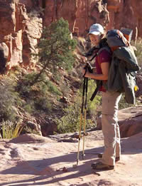
Clear Creek Trail view of Black Bridge, Silver Bridge, and a piece of the South Kaibab Trail.
I have made considerable progress on the Grand Canyon web pages on this blog. I only have my last hike, the 2009 hike with Vivian to Cheyava Falls, to write about. Here is a beautiful photo of the Black Bridge that we captured on the morning of the last day of our hike. On the far bank the South Kaibob trail can be seen winding it’s way upwards. That day was exhausting. We arrived at the South Kaibob Trailhead at 7:00 and had started at 7:00 AM.
My next project will be the Appalachian Trail pages. I began that hike in 2004. This July will be my 6th year on the trail and I expect to hit the half-way point. This is probably more than I had expected as it is a challenge to do this each year. And, it’s not getting easier.
Vivian and I returned last Thursday after a grueling 6 days and 5 nights in the Grand Canyon. The hike to Cheyava Falls was challenging but certainly a great adventure for the both of us. I am currently going through our photos to prepare a DVD for Grandma and eventually a page describing the hike here. For now here is a color coded topo map from our GPS tracks of our hike.
Red = Bright Angel Trail
Green = Clear Creek Trail
Purple = Cheyava Falls via Clear Creek
Yellow = Colorado River via Clear Creek
Orange = South Kaibob
The Cheyava Falls and Colorado hikes were both done by following Clear Creek. This involved a bit of bush-whacking and some route finding to get to Cheyava Falls. My hike to the Colorado was stopped a mile short by a 15 foot pour off. There was a rock climb passage down the west side but it was steep and I was unsure of getting back out and back to Vivian at the Clear Creek Camp. The National Park flyer states to stop here if you are not comfortable with rock climbing. Duh.
The final hike out was quite difficult. We left the AK9 campsite and hiked 2 miles to Phantom Ranch in the early morning of March 17. We exited the canyon around 6:30. It was a tough, steep hike out and the packs were heavy.
I spent this morning running errands and finalizing purchases for the Grand Canyon 2009 hike to Cheyava Falls. Goode Sport coupon was good for a hat and Mountain House Food and also a stuff sack for my tent. I believe we’ve got what we need and when Vivian and I pack up at the motel on Wednesday afternoon we can run out and purchase any other items necessary. Of course, I’m assuming we will be in Tuscayan at the Seven Mile Inn.
Vivian arrives tomorrow in the late afternoon. I am currently writing the Grand Canyon, March 2007 hike which is quite difficult as a lot happened on that hike and a lot happened leading up to it.
Today I am attempting to concretize the hiking permits for Vivian and I to go to the Grand Canyon over the upcoming Spring break. The process has not been a smooth one as the original hiking permits, approved, no longer worked for us. We have different spring breaks this year and I mistakenly organized a trip under the assumption we would be off at the same time. In one sense it is a good thing because for some reason my trip itinerary was ridiculous. I had us starting down the Grandview Trail and then heading over to the Kaibob and across to Phantom Ranch. I only allowed one overnight for this but if I had a closer look at the map I would have realized that we would need two overnights just to get to the Phantom Ranch area from the Grandview. That would be a trip in itself and there is no need to mix it up with a Cheyava Falls trip. The new request has a problem with the dates so I am going to phone them right now and see if I can nail down the dates. Hopefully we can do this Cheyava Falls trek.
OK, just now got off the phone with the Grand Canyon park ranger and we are set with our permits. We will be hiking into the Clear Creek area (down Bright Angel early morning of the 12th) and stay somewhere outside of Phantom Ranch where we can. Day two we will hike to Clear Creek and set up camp. Day three we will hike to Cheyava Falls and hope that the falls are running. Day four we will begin the trek back and Day five we will exit by way of the South Kaibob Trail.
Sophi and I had an adventure March 14-19, 2008, as we hiked the Royal Arch Route for 5 days and 4 nights. I will create a page tab dedicated to the Royal Arch when I find the time. Currently we are involved in creating a DVD that we narrate so that we can share it with the family. Once that is done I can post a page on this site.
Sophi at first pour over.
In short, each day was an adventure. Day one involved snow, ice, route finding on the pack trail, and getting befuddled at the same pour over that caused me to make “the Jump” last year—the photo shows Sophi at that pour over. The second day was all boulder hopping. We did get to the Natural Arch but did not make it to the rappel area until the Third day. Much of the adventure comes from boulder hopping as each boulder blocking the creek bed posed a new problem to solve and overcome. The third day we hiked from just above the rappel to Elve’s chasm and backtracked some to Garnet Canyon. This was more boulder hopping, not quite as severe but very trecherous. Much of the rocks we scrambled over were basaltic and ripped at our clothing and shoes. From Garnet we found our way out and had to do some route finding (no cairns or discernable trail) to work our way to my campsite from the year before, where we brunched. This was to be a gruesome day as we had very little water. The canyons provided no relief for us. So, all day we rationed. We arrived at Bass Canyon at a water hole I had marked the previous year at about 7:30 PM. The next day was all up hill as we hiked out.
I look forward to providing more details and photos in a static page.
Yesterday I spent the AM in Government Canyon. I was hoping to get some flower shots but nothing was blooming except a few Mountain Laurel, a scattering of daisies, and a smidgen of verbena.
Our flight leaves for Las Vegas, March 13, 2008, early in the morning. We will drive an All-wheel SUV from Las Vegas to Tusayan where we will stay the night. The next morning, early, we will leave for Pasture Wash (park dirt road) and cross the Havasupai Indian Reservation to reach the trail head for the Bass Trail. We should be on the trail in the early morning.
I hiked the Royal Arch Loop last year at this time and it was the toughest hike I have ever done. The trail leading down the canyon is not really a trail, it is a tributary to the Royal Arch Creek and the Royal Arch Creek itself. It is strewn with boulders and deep drop offs. It becomes a trail of commitment as it is very difficult to retrace your steps.
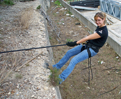
Practice for the Royal Arch
The second day we should reach the natural arch. I’m hoping to get many outstanding photos of it and the trail itself. Later in the second day there is a 20 foot drop that requires ropes. Sophi and I practiced roping by going over to Lowes at Bandera Point (San Antonio, Tx). She did very well—great form. She is not afraid to lean over the edge and then walk down the side. The third day we will hike along the Colorado to Elve’s chasm. I hope we can go up Elve’s chasm a bit to see the natural arch from a different vantage point. We will then head for Garnet Canyon and pick up the Tonto trail at its western-most point. The next day is a hike along the T0nto to the Bass Canyon where we will hike out. It should take us 5 days hiking and 4 nights. We are psyched.
The celebration is planned at Pasta-to-go in Tusayan. For the past several years it has become a tradition to celebrate hikes by feasting at this wonderful restaurant. Spaghetti dinner, salad bar, beer on tap!!!