Posted on

Royal Arch Loop, Part III

Grand Canyon 2008 Royal Arch
Sophi on the South Bass Trail. (Royal Arch 2008).

Today I received the Backcountry Permits for the Royal Arch Loop. This will be my third time to do this incredible hike and this time Jesse will be joining me. The permit is for Monday 3/15/10 and out Friday 3/19. I remember very well the first time I did this hike as it was on my mind for almost the entire year before I made it. When I had completed the Bass Trail hike in March 2006 the seed had been planted to do the Royal Arch. It was the most anticipated hike/adventure I ever had. Since that time I have read a bit about other people’s experiences on the hike. Check out  SummitPost-Royal Arch Loop September 2006.  This group of 6 tried to hike out the wrong canyon (see day 6 entry). And then there is the couple that got lost in the canyon doing this hike. They were in the canyon for 9 days. They evidently missed Bass Canyon exit which baffles me. The best I can make out after reading various blogs is that they tried to exit out Serpentine. To their bad luck they were hiking out (not really lost after all) and were within an hour of the trailhead where they left their SUV when a park ranger encountered them and then the hoopla began. They were on Good Morning America and that’s how I found out about them. Somebody at work said that a couple got lost on the same hike Sophi and I did. So we checked out Good Morning America and sure enough, they were interviewed. There are quite a few articles about this on the Internet. Try Couple That Was Lost In Grand Canyon. Also an interesting account of a disastrous trek on the Royal Arch.

Posted on

Redemption

Appalachian Trail 2006
View from Buzzard Rock on Whitetop Mountain, on the Appalachian Trail in Southern Virginia.

I finished another AT section page a week or so ago. I themed this one Redemption. I didn’t realize until I was putting the page together that I had a very successful section hike in 2006. I completed 180 miles, had just a single zero day, and no major gaffes or equipment errors. This hike took me into Southern Virginia. See the page.

Posted on

AT 2005—The Debacle

Appalachian Trail 2005
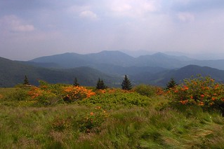
On the Appalachian Trail in the Roan Highlands. Hiking with the left foot in Tennessee and the right foot in North Carolina.

The AT 2005 page is now posted. It took a bit of reconstruction but I had enough information between my meager notes, GPS data, and some earlier work I had done by mapping my hikes in Google Earth.

This section hike was my most unproductive. I drove out to the trailhead (near Erwin, Tennessee) and that cost 4+ precious days of a 14 day vacation period. Then I had two zero days needed to recover from not pacing myself in a rational manner.

But, this was offset by the beauty of the hike, the most beautiful section hike I’ve encountered to date.

See the posted page AT 2005.

Posted on

AT 2004 page ready

In June and July of 2004 I hiked the Appalachian Trail from Springer Mountain in Georgia to Sams Gap in Tennessee. My intention was to eventually make a web site, when I got around to it, but never really seemed to get around to it. Now it is 2009 and I am finally getting the 2004 section up.

This was my first experience with this type of hike and I made all the rookie mistakes—too much equipment, over confidence in one’s own abilities, and underestimation of the difficulty of the Appalachian Trail. It is not an easy hike. I know this first hand.

My first section hike was 30 days and I covered 315.3 miles. The AT 2004 page provides many details about this experience and a link to my flickr album.

Posted on

AT 2009 Page Ready

Appalachian Trail 2009
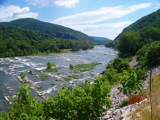
Shenandoah River, on the AT in West Virginia, July 7, 2009.

 I returned from the Appalachian Trail (my 6th section hike) this past Wednesday, July 15 around 11:00 PM and was back to work the next morning. This evening I created the page (AT 2009) that documents the hike, which was quite a momentous one.

This is the first Appalachian Trail page I have completed. I will be attempting to catch up and document the other 5 legs over the next few weeks.

As I have told many people, there were several milestones achieved during this section. Among those would be the 1000 mile mark, Harper’s Ferry, and the mid mark of the AT. I did very well and hope that section hike 7 will be even better. I can use some things I learned on this hike to hike for a goal, plan my hikes ahead so I hit key areas for washing clothes, showering, etc. without getting surprised, and to pack better food.

Posted on

Report from the AT

I just arrived near Smithsburg, Maryland at a hostel 3/10 of a mile from the AT. I have showered and am in the process of washing my clothes and have ordered lunch delivered from Vince’s New York Pizza in Smithsburg. This gives me a chance to refresh and knock some of the dirt off.

My time on the trail has gone well. I am a bit ahead of schedule for reaching Boiling Springs on the 14th. This morning I hiked in from Pine Knob shelter near US 40 and Greenbrier State Park. That is 8.2 miles. I hope to get near the Pennsylvania border this evening. I still have to dry my clothes, eat lunch, repack a bit and then I can take off. I should be back on the AT by 2:00 or so.

In general, things have gone well. I purchased food that was mediocre-I hope I can avoid doing that. But there have been numerous opportunities to get off the AT and get something to eat so I certainly haven’t suffered. I did just weigh myself and am down to 180 so I am 10-12 pounds below my normal weight. Unfortunately my normal weight is a bit heavy. I did let the phone discharge which is aggravating. But I only need that to call the shuttle driver and I most likely won’t have the need to do that since I see a clear shot into Boiling Springs, about 67 miles north of here. I still have 5 full hiking days plus this afternoon so that should be no problem.

Well, I’m glad I had this chance to blog from the trail itself. I expect to be back home in San Antonio on the 15th.

Posted on

Appalachian 2009

This week I’ve been making preparations for the upcoming July 1 leg of the Appalachian Trail. This will be my 6th year of section hiking.

Preparations have been both mental and physical. I am completing the 7th day (of 7) of the Scarsdale diet and have my weight down to 186. I think that will be ideal for hitting the trail.

Planning this section hike has been more difficult than past hikes. This seems contradictory as one would think I would pretty much have a routine now. But, with the price of rental cars being so high I’ve decided to go straight shuttle drivers. I did this on the first section hike and there is no reason it won’t work to my advantage on this hike. For some reason I am all business about the 14 days I will have out on the trail. I want to make good progress, no zero days, but I also don’t want to kill myself. In that respect, the past 5 years and all the Grand Canyon hikes will serve me well as I plan for equipment and food.

My backpack is ready to go, food is purchased. The checklist I have developed has been a great help. Just a few remaining items to put in the airline luggage and I’ll be off.

I have made arrangements with a shuttle driver from Boiling Springs, Penn. He will pick me up at the airport at 1:00 PM on July 1 and drop me at Thornton Gap. He will take the one suitcase I will have and drop it at Boiling Springs (that is where he is from) at his parent’s bed and breakfast. I have a room reserved for the 14th at their bed and breakfast. I am not sure if I can walk that far (180 miles) in 14 days but it certainly is possible. But, in any event, if I don’t get that far I’ll exit the trail and get over to Boiling Springs to make sure I can get cleaned up and a night’s sleep. The same shuttle driver will leave me at Dulles Airport the following day (July 15). I will arrive back in San Antonio late and be at work the next morning. So, the hike will be packed into those few precious days. I know it will be tough back at work but the purpose of this is to hike the trail, not laze around.

My next posting should detail my success with this section of the Appalachian Trail. It is a momentous leg because I will enter Harper’s Ferry and also pass the 1/2 way mark of the trail. I will be in 4 states and expect to have some good photos for the pages I design for this blog.

Posted on

Grand Canyon Pages Progressing

Grand Canyon 2009 Clear Creek
Clear Creek Trail view of Black Bridge, Silver Bridge, and a piece of the South Kaibab Trail.

I have made considerable progress on the Grand Canyon web pages on this blog. I only have my last hike, the 2009 hike with Vivian to Cheyava Falls, to write about. Here is a beautiful photo of the Black Bridge that we captured on the morning of the last day of our hike. On the far bank the South Kaibob trail can be seen winding it’s way upwards. That day was exhausting. We arrived at the South Kaibob Trailhead at 7:00 and had started at 7:00 AM.

My next project will be the Appalachian Trail pages. I began that hike in 2004. This July will be my 6th year on the trail and I expect to hit the half-way point. This is probably more than I had expected as it is a challenge to do this each year. And, it’s not getting easier.

Posted on

Appalachian 2009 Preparation

The time for departure for the Appalachian Trail is rapidly approaching. I’ve printed out my calendar and checklist, ordered a book (Mid-Atlantic States) and have been getting my mind focused on this event. I leave on Wednesday, July 1and return on the 15th. So that really isn’t very much time but that is all I have to work with. My plan is to maximize the time for the trail.

I will begin at Thornton Gap. My tentative plan is to use mass transportation to get to Harper’s Ferry, cache my travel bags, and shuttle to the Gap. Thornton Gap is at the 929.9 marker from Springer Mountain. Harper’s Ferry is listed at 1011.5 from Springer. So that means a march of 81.6 miles. This will be a momentous passage as Harper’s Ferry is the HQ for the ATC and an important milestone.

The halfway point of the trail is 1087.7 near Halfway Spring in Pennsylvania. I should not have any problems making that, as a minimum and would actually expect to get further, perhaps Boiling Springs at 1109.7. That would be 179.8 miles which is certainly doable. Boiling Springs appears to be a main thoroughfare and perhaps I can get public transport to Harper’s Ferry.

I am looking at public transportation this time because the rental car is very expensive, over $600 for the little bit I would use it. The problem with the public transportation is the time it eats so at this point I’m not sure what I will choose.

Posted on

Texas Walking Sticks

Government Canyon
Texas Walking Stick, Government Canyon.

When I arrived at Government Canyon in the early morning (around 7:00) last Sunday, I was greeted at the visitor’s entrance by a batch of Texas Walking Sticks. They were just hanging around enjoying the cool morning. They are a very curious creature.


Government Canyon
Texas prickly pear (Opuntia engelmannii), Govenment Canyon.

Government Canyon has profited from a bit of rain this past week. More flowers are in bloom, especially the yellow cactus flowers. And it is beginning to heat up a bit. Thankfully they open at 7:00 AM now and that really helps.